Hoganas to Odense
Route: ESMH COAST TNO DCT HAVNEMARK DCT LUMBY DCT EKOD
Capacity: SNY (Self-loading freight)
Thursday morning in Hoganas was fabulous, CAVOK and warm, clear skies. But the front that threatened to come through from the west was slow moving and appeared to be over mid-Denmark. The METARs from the airfield near our planned destination of Samso island were not good, but it was not clear how much of the low cloud was due to early morning for burning off (the temperature and dewpoint were very close) and how much may be due to the front.
As the morning wore on the METARs improved, but only slightly. We may have been able to get through or certainly to divert to one of the many airfields en-route in Denmark, but should we? It wasn’t my leg to fly and we eventually settled on leaving it for today for the front to pass through where we were in Hoganas overnight. Instead it was take to the bikes and pedal along a coastal cycle path (converted railway) from Hoganas to the village of Molle near the tip of the peninsula some 11km away.
It was glorious sunshine until mid / late afternoon when the front finally came in and clouded over as the temperature cooled noticeably (fine by me, I don’t like it too hot) and the wind picked up. So far this entire trip, I had only worn polo-shirts, I didn’t need the fleece I brought with me.
The final planned day of our tour of Friday dawned with a modest wind and broken cloud at about 2000’. The front had passed and we were seeing the back end of it. We checked the weather and synoptics which confirmed this, but they also showed a ‘trough’ hanging around over northern Germany, but clearing nicely to the west of there. We decided to try to make it back to the UK in three or four hops, depending on the weather and ceiling in the North Sea. First leg was to fly to Odense to get a decent fuel load, then Odense to Texel, then if the North Sea was OK for weather and ceiling, direct across the North Sea to Gloucester, or if not route via Calais, then back to Gloucester.
The METAR’s indicated a ceiling of about 1000’ at Odense with a fair old wind, but good lateral visibility. We took off and flew this leg. The cloud was broken and thin and we could have got between layers, but carried on at 1500 – 1000’. We crossed to Fyn Island and picked up the airfield information. The wind was running at 280 / 18, nicely bisecting both the main hard runway and the secondary grass runway, so we would have a crosswind whatever we did. We made a nice crosswind landing on the main runway and parked up and refuelled. Odense is yet another huge regional airport that is practically deserted.
Odense to Texel
Route: EKOD DCT EDXF DCT EDXJ DCT EDXM DCT BEDERKESA DCT LANGWARDEN DCT VOSLAPP DCT SPIEKEROOG DCT FRISIAN ISLANDS DCT EHTX
Capacity: P1 (Pilot)
Logged time: 2.6 hours
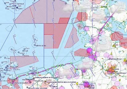
Route from Odense (Denmark) to Texel (Holland)
The next leg was mine and we planned to fly from Odense to Texel, which once past Flensburg, was virtually retracing our steps on the flight coming out. I did some more flight planning using the internet PC at Odense. The wind seemed to moderate a bit at Texel and was positively calm in the UK. It seemed the further west we went, the more the weather improved, so it was looking OK for a possible North Sea crossing. The METAR’s and TAFs were hedging their bets as usual in the trough around Northern Germany and talking about TEMPO CB etc. In my judgement, it was well worth a look as there were plenty of airfields to divert to en-route. I filed a flight plan and we loaded up again.
The wind was pretty much the same, not so much gusty as fairly steady at 280 / 18, so a 15kt crosswind component take off whichever runway I chose, I could see that it favoured 31 slightly, but I decided to stay with the hard runway on 24. Power checks complete, we lined up and were cleared for take off. I powered the engine up and held what I judged to be the correct amount of into wind aileron and danced on the rudder bars to stay pointed down the end of the runway and counteract the crosswind from the right. The tail came up quickly as I focused on a point at the end of the runway to keep the nose pointed at using the rudder.
Whether it was me or the wind (probably both) the nose swung a bit first one way then the other (possibly as I over-corrected), but it was OK, if not elegant. The plane started to hop quite early, so I started to ease her off, but I was premature and all she did was sit tail-down for a few seconds. Then bless her, just as I was about to level out again, she hopped into ground effect, so I held her there and was pleased that at least I got the aileron right as there was no wing dip or lift. She settled and I eased her into the climb, pretty glad to be away from the runway. Not one of my better take-offs, but we were away. The cloud was higher and we easily climbed to 1500’ for an orbit of the airfield for a few photographs.
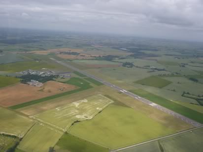
Odense airfield
I set course for roughly Flensburg and spoke to Skrydstrup Approach. I managed a climb to 2000’ and again held that for pretty much the rest of the trip. At some stages I could have gone higher, but at others I had to dip lower under small showers, so 2000’ was fine.
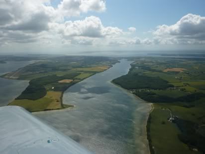
Denmark around Als Fjord near Sonderborg
Around the border between Denmark and Germany at Flensburg, I tried to contact Bremen Information, but no joy. It took three attempts over ten minutes to raisde them, not that I was worried at all, just keen to try to speak to someone during a border crossing.
I set course pretty much directly from Flensburg to St Michaelisdonn airfield just north of the Elbe estuary. From there I hopped across to Bederkesa Lake, then across the Weser estuary near Bremerhaven to Wilhelmshaven, then north west to pick up the Frisian islands.
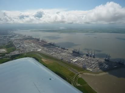
Bremerhaven
We followed the line of the Frisian islands, occasionally ducking to 1200' to get under a small shower cloud, other than that it was fine at 2000'
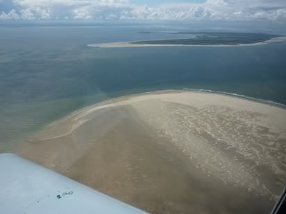
Frisian islands
It took a fair while and several attempts to get through to Dutch Military, I suspect that their reception at low level along the easternmost Frisian Islands is poor. They eventually cleared me through danger area R4A and on to Texel island.
Just coming on to Texel island, I spotted something that looked like a Fournier motor glider climbing up towards me. I took immediately evasive action, although it was not what I would call an airprox, but it would have been if I hadn't have moved and maybe worse. Another remonder if I needed one (which I don't) that visual flying means getting your head out of the cockpit!
I picked up the weather actuals and runway at Texel. They were using the shorter grass runway, 31 (630m so still plenty) and the wind - 310 / 18 - ouch! Thank heavens it was straight down the runway!
I joined base for runway 31 and managed to land first time and trundle to the end to park up at the pumps to fuel for the next leg. A rather nice 2.6 hour leg in reasonable weather. Enjoyed that!
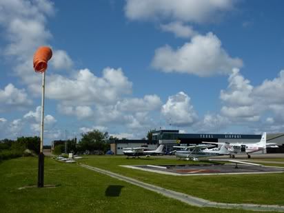
A fair old wind a Texel
Texel to Gloucester
Route: EHTX DCT RAVLO DCT NORWICH DCT DTY DCT EGBJ
Capacity: SNY (Self-loading freight)
This was the last leg of the tour and my group colleague was flying this one. It was pretty much a backtrack of our original route out as the weather over the North Sea looked fine enough to get a decent amount of height.
In the end, he went for FL45. We took off as soon as the planning, final met checks and flight plan were completed. We climbed en-route and leaned out for FL45 and the return via RAVLO, Norwich and Daventry.
The interesting part was some of the vertically developed cumulus clouds, so we avoided the taller ones, which were pretty well scattered anyway.
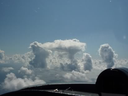
We'll be keeping clear of those then!
The wind had died down a lot over the UK, but then lateral visibility started to clag up a bit, still fine, but not gin-clear. We dropped to 3000' or so for the remainder of the track back into Gloucester.
On arrival at Gloucester at about 17:30 local, it was out with the water and sponges to get half the world's popultation of flies off of the leading edges of the plane and canopy.
The end of the 2011 Scandanavia Tour!
