Well, that is my ‘big trip’ for 2007. This year, I had to ‘pivot’ around seeing our friend and neighbour in Lausanne, Switzerland. A quick look at the map for the one week trip showed the options to be limited, given that we wanted to spend at least one, preferably two days in each location and to try to avoid two leg days.
Given these constraints, I decided on Koblenz (as I had heard so much about it) and Dan fancied Chateau Chambord, so Blois in the Loire Valley was the other destination.
With hindsight, we didn’t need as many days in Koblenz and could have tried for a night somewhere else in Germany headed towards Switzerland, but there you go.
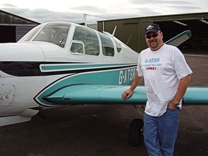
I accumulated to total of 9 hours ‘loggable’ flying time over a total of four legs over one week. The longest leg was just over 2.5 hours and there was plenty of fuel left. I would be quite confident of flying a three hour or a three-and-a-bit hour leg in the Bonanza now (yes, its got a fuel flow wotsit, but it is a real confidence builder to eyeball and dip the remaining fuel).
This was the first time I have flown in a small plane to either Germany or Switzerland and certainly my first time getting up close and personal to some serious mountains.
All in all, it was a great trip. Maybe not a ‘epic’ as the 2006 Flyer Forum trip to Italy, but then it was never planned to be.
Well since Dan is ‘banned’ from coming back to Europe next year without his wife and I don’t want to play ‘gooseberry’, I think my big trip next year may have to be with my wife (she might come) or maybe a fellow pilot. I’ll look out to see what Flyer Forum may have planned and maybe hook up with that. Mind you, the wife is talking about a tour of northern Spain, so flying may be a good option. Wait and see really.
I hope to get a trip to Deauville / Honfleur with the wife and may try to take my neighbour on a battlefields tour of the Normandy beaches.
Monday, August 06, 2007
Sunday, August 05, 2007
Big Trip 2007 - Le Touquet to Gloucester
1.6 hours logged
LFAT DCT ALESO DCT SFD DCT GWC DCT EGBJ
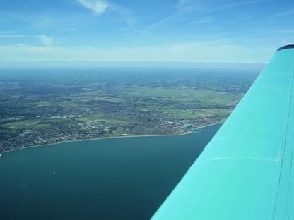
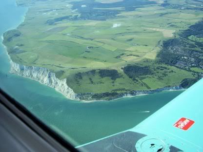
Well I have done this route a few times now! The weather was excellent, clear skies and probably the best visibility I have ever seen over the channel.
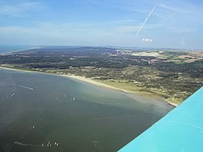
Took off and climbed to 4500’ and proceeded to sit there for the whole trip. I was expecting clouds over the UK and that is what it looked like, but it was only the effect of looking ‘edge-on’ at the cloud layer, when I got to where the clouds should be, they weren’t there, but further on and so on.
Farnborough Radar were frantically busy and I barely managed to get the call in. I really do take my hat off to UK controllers – they do a fantastic job (oh, and Langen Info as well, although they were far from busy).
Asked for and got a transit through the western edge of Brize Zone to stay well clear of parachuting at South Cerney.
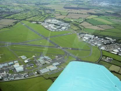
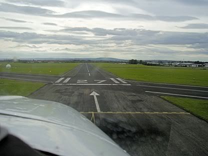
Check the Gloucester ATIS and got a standard overhead join for 27. Good approach, but a bit fast and was penalised with a ‘floaty’ hold-off and a landing past the first intersection.
We parked up and pushed back into the hangar. While I completed the logs and other formalities, Dan unloaded and cleaned to perspex and leading edges of the wings (by now these we covered in fly-splats).
The very nice lady on reception at Gloucester was quite taken with our, by now pretty smelly, team t-shirts and Bavarian hunting hats (note to self..... get more than one t-shirt made up for each of us next time!).
A nice easy run back into Gloucester on the planned date.
LFAT DCT ALESO DCT SFD DCT GWC DCT EGBJ
Well I have done this route a few times now! The weather was excellent, clear skies and probably the best visibility I have ever seen over the channel.
Took off and climbed to 4500’ and proceeded to sit there for the whole trip. I was expecting clouds over the UK and that is what it looked like, but it was only the effect of looking ‘edge-on’ at the cloud layer, when I got to where the clouds should be, they weren’t there, but further on and so on.
Farnborough Radar were frantically busy and I barely managed to get the call in. I really do take my hat off to UK controllers – they do a fantastic job (oh, and Langen Info as well, although they were far from busy).
Asked for and got a transit through the western edge of Brize Zone to stay well clear of parachuting at South Cerney.
Check the Gloucester ATIS and got a standard overhead join for 27. Good approach, but a bit fast and was penalised with a ‘floaty’ hold-off and a landing past the first intersection.
We parked up and pushed back into the hangar. While I completed the logs and other formalities, Dan unloaded and cleaned to perspex and leading edges of the wings (by now these we covered in fly-splats).
The very nice lady on reception at Gloucester was quite taken with our, by now pretty smelly, team t-shirts and Bavarian hunting hats (note to self..... get more than one t-shirt made up for each of us next time!).
A nice easy run back into Gloucester on the planned date.
Big Trip 2007 - Lausanne to Le Touquet
2.6 hours logged
LSGL DCT YVERDON DCT RLP DCT CTL DCT LFAT
We had only planned to stay in Switzerland for two nights, departing early Thursday to go to Blois in the Loire Valley to see Chateau Chambord. The Wednesday in Switzerland was fantastic, warm and sunny with a clear sky and great visibility. When I checked the forecasts on the internet, I got conflicting views. The BBC said clear and sunny the next day, but Swiss Meteo said cloudy with thunderstorms. Our host said that it rarely ‘socked in’ for a day and that if there were storms, they often broke up quick with good weather or at least very large breaks between. So we decided to try for it. We contacted Blois and arranged customs clearance (as this was a prior notification airfield) the previous day.
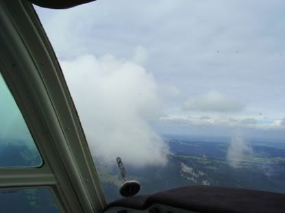
Thursday dawned tipping down stair-rods with thunder and dramatic fork-lightning. Thinking this might break up, we got a lift to the airfield and waited. And waited and waited and waited.
I wanted a break with higher clouds and a clear view of the Jura ridge we had to cross. I probably saw this once, but with lightning still around and more low cloud about to roll through, there was no way I was even going to start prepping the plane, let alone take off.
I was astonished to see a small plane fly over the airfield not more than 1000’ above with lightning going off all around and I was hardly surprised to see him land 4 minutes later. I guess he was a local Swiss guy, but why he took off in the first place eludes me!
By 12:30, if anything it was worse and rather than lose a whole day, we decided to give it up and hire a car and do our own thing. So that was the last part of the trip cancelled. I only had the plane booked for Friday (not Saturday) and had to have Dan back in the UK by Saturday at the latest for his Sunday flight back home, so re-planning was called for. I legged it out to the aircraft, only to be beaten back once out on the apron by frequent fork lightning all around and me realising what a great target I was all alone on a high airfield on a nice, flat apron!!
I planned a route back to ‘good old’ Le Touquet then on from there to Gloucester. By way of recompense for not staying in France, we thought we would have lunch in Le Touquet if the weather was OK. So I re-planned the route accordingly. Pretty much a straight line following VOR’s to the North West.
Next day, the weather was much better. Not brilliant sunshine, but cloud that was clear of the ridge anyway. I printed the weather off for Europe and the UK from the house on the internet (UK Metoffice site) and went to the airfield again. I paid up, and completed the customs departure form.
To file a flight plan, you have to use one of the two dedicated internet terminals permanently connected to the Austo-Swiss site. The logon and password are pasted onto the terminal and completing the flight plan was simplicity itself – why can’t we have this in the UK??
I checked the plane and emptied most of the water ballast as we were taking yet more goodies and Swiss wine back. I added 1 Qt of oil and carefully checked the fuel tanks for water several times from the fuel drains after the previous days downpour. Not a trace, how wonderful!
Again, Launsanne was operating like an uncontrolled airfield (only this time they mentioned it on the ATIS!). So I started up and taxied out. There was little wind, but take off was to be uphill on 36 (probably the preferred runway for noise abatement reasons). I gave the usual blind calls, did the power checks, checked the circuit and final approach track carefully and lined up on 36.
I started the take-off run and noted the manifold pressure was not as high as normal. I immediately realised that this was due to the pressure altitude, which while not that high, was clearly high and hot enough to affect this. I decided it was not pronounced enough for me to abort the run and try leaning for take-off so elected to continue – making a large mental note to think this carefully through beforehand next time!
Heading uphill, I nursed the plane into the air with the odd ‘chirrup’ from the stall warner as I was keen to get the gear up to reduce drag (not too close to the ground mind you!). This had the desired effect and I was climbing away nicely.
I switched to Geneva Info who could again hardly conceal their lack of interest! After picking me up on my pronunciation of Yverdon (apparently it should be EEEE – VARE – DONN with an emphasis on ‘DONN’ – are all French speakers a pain in the butt like this?), they asked me to report at the Swiss border.
OK, I am going to have a rant! Why is it that French speakers insist on perfect grammar and pronunciation before they will deign to understand you? I spoke my very poor German in Germany and was usually rewarded with a charming smile and a nod of understanding and with them offering to speak English to put me out of my misery – the French? Oh No!!! Even Dan get a similar response – and French is his native language (OK, OK Quebecois), but really!! To be fair, the French in La Rochelle were an exception.
Up to 4500’ at Yverdon on the shores of Lake Neuchatel and spotted the airfield there. Climbed to 5000’ and spotted the same valley in the Jura that I came through, so let’s use that! Parts of the ridge had some scattered cumulus sitting on them (cumulus granitus!), but the bit I was aiming for was mercifully free of such entertainment. I squeezed through the valley and seven minutes later as the ground was dropping slowly away, crossed the border into France.
As the land dropped away, so too did the cloudbase. I had to descend to 3500’, then 3000’ then 2500’ bumping my head on the clouds. We chugged along at about 145kts airspeed and 155kts groundspeed according to the GPS and played my favourite airborne version of ‘knock knock, ding-a-ling, cheers’ by seeing who could spot the airfield first – my how the time flies!
I spoke initially to Reims Info on 124.10 then past RLP to Paris Info on 126.10. Both of whom were very helpful.
It was a nice, easy run and we were soon in the Champagne district with loads of fields of vines everywhere and large, imposing chateaus.
With 25 miles to run, the weather improved and I could see ahead to the coast that it was clear skies – WOO HOOO!. So I contacted Le Touquet – HORROR! The dreaded female controller was on!!
They were busy, I’ll grant you. But she was up to her old tricks of unnecessary and detailed parking instructions and other trivia, clogging up the airwaves so few people could get a word in. Mind you, some of the pilots on frequency need to listen out and pick up their calls first time, that added to the congestion.
Runway 32 was in use and I was approaching on what was a very long final. She helpfully asked me to hold at 10 miles for an extended final approach – fine by me, that’s what I was hoping for. So I took up right hand orbits. I did about three and with Dan starting to look a little green, finally got a call from her asking me where I was (thinks.... where you left me – where do you think!). I replied I was orbiting at 10 miles and she directed to me approach and report at 3 miles. This I did and got a straight to final approach.
Made a good approach and landing, taxied and parked up. No customs, no hassle as we got a taxi into town for a stroll and a nice pavement lunch at one of the many cafes in town. Bought yet more wine and chocolate (for the wife you understand!) and headed back to the plane about 15:30 local in glorious sunshine.
So, small recompense for missing out on Blois and the Loire Valley (note to self – I need to do a serious tour of the various towns and airfields in the Loire Valley). Le Touquet really is a very nice town and well worth a visit in it’s own right and not simply to get the charade of clearing customs over with then dash on to your destination.
So disappointing not to make Blois, but I was worried about getting out of Switzerland. I certainly wasn’t going to chance anything with thunderstorms about. Having said that, without a full IR (I am IMC only), that is what touring in Europe means, go for it, but give yourself flexibility to deal with the weather.
LSGL DCT YVERDON DCT RLP DCT CTL DCT LFAT
We had only planned to stay in Switzerland for two nights, departing early Thursday to go to Blois in the Loire Valley to see Chateau Chambord. The Wednesday in Switzerland was fantastic, warm and sunny with a clear sky and great visibility. When I checked the forecasts on the internet, I got conflicting views. The BBC said clear and sunny the next day, but Swiss Meteo said cloudy with thunderstorms. Our host said that it rarely ‘socked in’ for a day and that if there were storms, they often broke up quick with good weather or at least very large breaks between. So we decided to try for it. We contacted Blois and arranged customs clearance (as this was a prior notification airfield) the previous day.
Thursday dawned tipping down stair-rods with thunder and dramatic fork-lightning. Thinking this might break up, we got a lift to the airfield and waited. And waited and waited and waited.
I wanted a break with higher clouds and a clear view of the Jura ridge we had to cross. I probably saw this once, but with lightning still around and more low cloud about to roll through, there was no way I was even going to start prepping the plane, let alone take off.
I was astonished to see a small plane fly over the airfield not more than 1000’ above with lightning going off all around and I was hardly surprised to see him land 4 minutes later. I guess he was a local Swiss guy, but why he took off in the first place eludes me!
By 12:30, if anything it was worse and rather than lose a whole day, we decided to give it up and hire a car and do our own thing. So that was the last part of the trip cancelled. I only had the plane booked for Friday (not Saturday) and had to have Dan back in the UK by Saturday at the latest for his Sunday flight back home, so re-planning was called for. I legged it out to the aircraft, only to be beaten back once out on the apron by frequent fork lightning all around and me realising what a great target I was all alone on a high airfield on a nice, flat apron!!
I planned a route back to ‘good old’ Le Touquet then on from there to Gloucester. By way of recompense for not staying in France, we thought we would have lunch in Le Touquet if the weather was OK. So I re-planned the route accordingly. Pretty much a straight line following VOR’s to the North West.
Next day, the weather was much better. Not brilliant sunshine, but cloud that was clear of the ridge anyway. I printed the weather off for Europe and the UK from the house on the internet (UK Metoffice site) and went to the airfield again. I paid up, and completed the customs departure form.
To file a flight plan, you have to use one of the two dedicated internet terminals permanently connected to the Austo-Swiss site. The logon and password are pasted onto the terminal and completing the flight plan was simplicity itself – why can’t we have this in the UK??
I checked the plane and emptied most of the water ballast as we were taking yet more goodies and Swiss wine back. I added 1 Qt of oil and carefully checked the fuel tanks for water several times from the fuel drains after the previous days downpour. Not a trace, how wonderful!
Again, Launsanne was operating like an uncontrolled airfield (only this time they mentioned it on the ATIS!). So I started up and taxied out. There was little wind, but take off was to be uphill on 36 (probably the preferred runway for noise abatement reasons). I gave the usual blind calls, did the power checks, checked the circuit and final approach track carefully and lined up on 36.
I started the take-off run and noted the manifold pressure was not as high as normal. I immediately realised that this was due to the pressure altitude, which while not that high, was clearly high and hot enough to affect this. I decided it was not pronounced enough for me to abort the run and try leaning for take-off so elected to continue – making a large mental note to think this carefully through beforehand next time!
Heading uphill, I nursed the plane into the air with the odd ‘chirrup’ from the stall warner as I was keen to get the gear up to reduce drag (not too close to the ground mind you!). This had the desired effect and I was climbing away nicely.
I switched to Geneva Info who could again hardly conceal their lack of interest! After picking me up on my pronunciation of Yverdon (apparently it should be EEEE – VARE – DONN with an emphasis on ‘DONN’ – are all French speakers a pain in the butt like this?), they asked me to report at the Swiss border.
OK, I am going to have a rant! Why is it that French speakers insist on perfect grammar and pronunciation before they will deign to understand you? I spoke my very poor German in Germany and was usually rewarded with a charming smile and a nod of understanding and with them offering to speak English to put me out of my misery – the French? Oh No!!! Even Dan get a similar response – and French is his native language (OK, OK Quebecois), but really!! To be fair, the French in La Rochelle were an exception.
Up to 4500’ at Yverdon on the shores of Lake Neuchatel and spotted the airfield there. Climbed to 5000’ and spotted the same valley in the Jura that I came through, so let’s use that! Parts of the ridge had some scattered cumulus sitting on them (cumulus granitus!), but the bit I was aiming for was mercifully free of such entertainment. I squeezed through the valley and seven minutes later as the ground was dropping slowly away, crossed the border into France.
As the land dropped away, so too did the cloudbase. I had to descend to 3500’, then 3000’ then 2500’ bumping my head on the clouds. We chugged along at about 145kts airspeed and 155kts groundspeed according to the GPS and played my favourite airborne version of ‘knock knock, ding-a-ling, cheers’ by seeing who could spot the airfield first – my how the time flies!
I spoke initially to Reims Info on 124.10 then past RLP to Paris Info on 126.10. Both of whom were very helpful.
It was a nice, easy run and we were soon in the Champagne district with loads of fields of vines everywhere and large, imposing chateaus.
With 25 miles to run, the weather improved and I could see ahead to the coast that it was clear skies – WOO HOOO!. So I contacted Le Touquet – HORROR! The dreaded female controller was on!!
They were busy, I’ll grant you. But she was up to her old tricks of unnecessary and detailed parking instructions and other trivia, clogging up the airwaves so few people could get a word in. Mind you, some of the pilots on frequency need to listen out and pick up their calls first time, that added to the congestion.
Runway 32 was in use and I was approaching on what was a very long final. She helpfully asked me to hold at 10 miles for an extended final approach – fine by me, that’s what I was hoping for. So I took up right hand orbits. I did about three and with Dan starting to look a little green, finally got a call from her asking me where I was (thinks.... where you left me – where do you think!). I replied I was orbiting at 10 miles and she directed to me approach and report at 3 miles. This I did and got a straight to final approach.
Made a good approach and landing, taxied and parked up. No customs, no hassle as we got a taxi into town for a stroll and a nice pavement lunch at one of the many cafes in town. Bought yet more wine and chocolate (for the wife you understand!) and headed back to the plane about 15:30 local in glorious sunshine.
So, small recompense for missing out on Blois and the Loire Valley (note to self – I need to do a serious tour of the various towns and airfields in the Loire Valley). Le Touquet really is a very nice town and well worth a visit in it’s own right and not simply to get the charade of clearing customs over with then dash on to your destination.
So disappointing not to make Blois, but I was worried about getting out of Switzerland. I certainly wasn’t going to chance anything with thunderstorms about. Having said that, without a full IR (I am IMC only), that is what touring in Europe means, go for it, but give yourself flexibility to deal with the weather.
Big Trip 2007 - Koblenz to Lausanne
1.9 hours logged
EDRK DCT KIR DCT GTQ DCT LUL DCT LSGL
While in Koblenz, we got back late one night (actually, make that early one morning!) and of course decided on a beer or three for a nighcap. We got chatting to the guy on the ‘graveyard shift’ at the hotel who served us and it turns out he too is an avid pilot. We talked about the next leg and he had been to Switzerland and Lausanne several times and rates it as his favourite destination. He was extremely helpful and brought in prints of plates and maps showing alternate route into Switzerland the next day that we talked through. Anyway, thank you so much for your help Rainer, it is always good to talk to someone who has actually been to where you want to go and pick up valuable tips – you made it easy for me!
We made our way to the airfield and loaded up.
I refuelled and paid up in the tower. I asked about weather (having checked it on the internet at the hotel) and they kindly printed the forecast and en-route TAFs and METARs. The weather for Switzerland was excellent, with clear skies and 40km visibility – just what I was hoping for for this, my first trip into Switzerland and some serious mountains (thinks, hmmmmm – when is a mountain not serious?).
I let out some of the water ballast to compensate for the various pressies we had bought (and no doubt the pounds we had put on in weight).
Just for the hell of it and because it is such a great approach, I asked for a take-off followed by a low approach and go-around, which they agreed to (my guess is that this is not an unusual request!). this I did while Dan snapped away furiously all the way around. I raised the gear and flew over the runway giving the tower a ‘waggle of the wings’ (I thought a victory roll inappropriate in a non-aerobatic plane!).
I set track for the KIR VOR, but swung deliberately east a bit to avoid Frankfurt Hahn controlled airspace.
The weather was good with high-ish broken cumulus and I was up to 4000’ easily. I could have gone ‘on-top’ but I was enjoying the view of the ground and was plenty high enough anyway, so why bother? I spoke to Langen Info on 123.52. It was a different controller this time, but again, very professional and helpful.
Approaching the border, I switched to Metz Approach on 125.90 and agreed a zone transit at 4300’. By now, the cumulus had changed to thin scattered cumulus and it was getting thinner and more scattered as I went south as predicted. I recall saying to Dan in Koblenz that just once, it would be nice to fly in a cloudless sky – someone must have been listening as that is what was happening!
I flew on past the GTQ VOR and contacted Reims Info. They immediately suggested I call Luxeuil instead. By the time I cut through their accent and found Luxeuil on the map, I was into their airspace with the airfield in sight – this was one I had missed somehow on the map in my planning! They were gracious about it and granted an immediate (and presumably retrospective) transit rather than scramble the Mirages!
I heard a familiar voice on the airwaves from another aircraft. It was Manuel Quieroz in his RV6, G-GDRV. I asked for and got an ‘air-to-air’ and said a quick hello. Manuel must have had trouble hearing the lady controller who asked several times for his full registration, so I relayed, deciding to help out this clearly inexperienced pilot – you really should get some hours in flying abroad Manuel (Manuel of course recently flew around the world in the RV6 in ‘Chasing the Morning Sun’!!!).
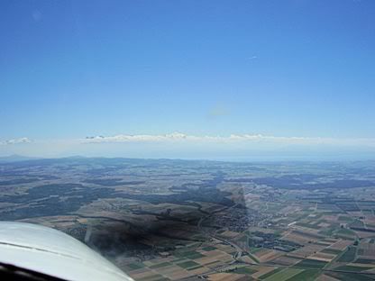
I went back to Reims Info as the ground got closer to the plane despite me flying at 4700’. It was getting more rugged as we approached the Jura Mountains. Reims got rid of me with 50nm to run to Lausanne and while still well inside France (cheers pal!). So I called Geneva Info on 126.35 who promptly suggested I contact Reins Info! I stayed on listening watch and Geneva Info couldn’t care less until you enter Swiss airspace (seems reasonable I guess).
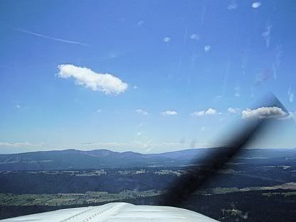
I was aiming for a ‘notch’ in the Jura Mountains ahead of me now. As usual, from this distance, it looked like I needed more altitude. I decided to climb to 5000’ and see where we went from there, as I would only have to lose it again fairly quickly to get into Lausanne, only about 25 miles inside the border (I didn’t want a repeat performance of getting into Cannes last year where I was at 8000’ when the mountains fell away to reveal Cannes airfield at sea level with 30 miles to run!). Closer still, I decided on 5500’ for the crossing. We saw Mont Blanc sticking up clearly through the inversion layer on the horizon.
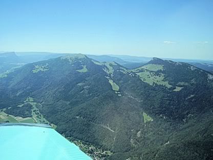
The ‘notch’ in the ridge turned out to be a small ‘pass’, so I used that and crossed the Jura Mountains with mountains above me on either side. By now, I was talking to a somewhat dis-interested Geneva Info who advise me to report at Yverdon on Lake Neuchatel.
I passed Yverdon and changed to Lausanne ATIS, picked up the ATIS and called the tower frequency. I heard a lot of calls, but no reply from the tower.
Descended to 3700’ as per the approach plates and approached for a left downwind join for runway 36 in use. I was still giving blind calls. While about 2 miles from downwind, I had a ‘close encounter of the brown trouser kind’ with a lovely yellow Piper Cub – only it wasn’t so lovely at the time. A classic case of ‘high wing below / low wing above’. I am sure neither saw the other until he had passed underneath!
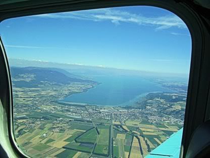
I carried on giving blind calls and realised that everyone else was doing the same, so despite the ‘Tower’ designation, it appeared to be operating as an uncontrolled airfield – not a problem, just not what I was expecting – and boy, was it busy! The weather could not have been better, with clear blue skies and unlimited visibility.
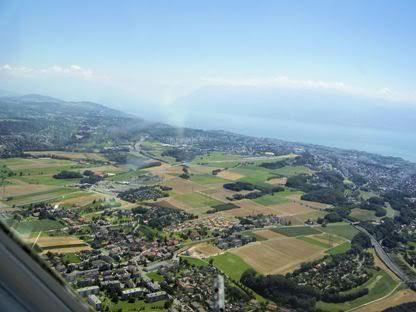
This was another interesting airfield. At 1800’ it is the highest I have been to. It is on the northern edge of the town or Lausanne on the shores of Lake Geneva. The runway is not overly generous at about 850m and has an interesting 2.5 degree upslope on runway 36 – so I was glad I wasn’t landing on 18!
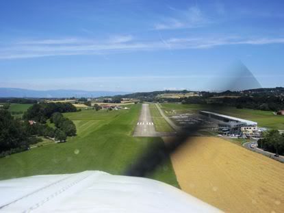
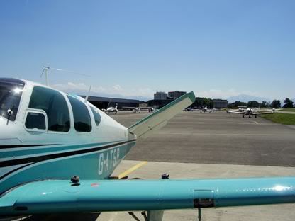
The approach is again very scenic, over the town while Dan was snapping away. I was ready for the optical illusion of an up-sloping runway and I mad e the final approach and gave my last blind call. This was rewarded by a good landing. As we wanted to get away early in two days time, I taxied straight to the pumps. Of course we had to get the keys from the tower, so Dan went off at a trot to collect the keys. He returned and we completed the refuelling easily enough and parked up on the carefully marked areas.
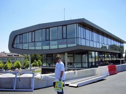
I checked into the reporting point in a smart, new terminal building where we filled out a customs arrival form. The lady told Dan (in French) that we had to wait for 30 minutes and if the customs officers didn’t show, we were free to go. There was a nice restaurant / bar downstairs, so it wasn’t a hardship. However, 10 minutes later, the lady appeared and explained that I might not have parked carefully enough. So she took me back to the plane in a car and inspected where the wheels were in relation to the ramp markings. Sure enough, I had missed the yellow line by about one foot, but she shrugged and said that was close enough – in broken English she explained that it was hard to see exactly from the tower and that space on the ramp was very tight.
We were met by our mutual erstwhile next-door neighbour who now works for the Olympic federation in Lausanne. We had arranged to stay with him and his family nearby and by coincidence, the next day was also Swiss National day with fireworks all over Lake Geneva.
The landing fee was SFr 32.00, Passenger Tax was SFr 6.10, Parking for 3 days was SFr 38.70 and there were minor charged for customs. All at a rate of around GBP 1.00 to SFr 2.35. Fuel was a bit cheaper but not hugely so.
My first trip in a small plane to Switzerland and my first bit of ‘serious’ mountain flying (no – I don’t count the Lake District or the welsh Hills), although I could hardly have chosen better weather for it, so not a huge challenge. But what a beautiful country and what fun it would be to land at other Swiss airfield – maybe next time!
EDRK DCT KIR DCT GTQ DCT LUL DCT LSGL
While in Koblenz, we got back late one night (actually, make that early one morning!) and of course decided on a beer or three for a nighcap. We got chatting to the guy on the ‘graveyard shift’ at the hotel who served us and it turns out he too is an avid pilot. We talked about the next leg and he had been to Switzerland and Lausanne several times and rates it as his favourite destination. He was extremely helpful and brought in prints of plates and maps showing alternate route into Switzerland the next day that we talked through. Anyway, thank you so much for your help Rainer, it is always good to talk to someone who has actually been to where you want to go and pick up valuable tips – you made it easy for me!
We made our way to the airfield and loaded up.
I refuelled and paid up in the tower. I asked about weather (having checked it on the internet at the hotel) and they kindly printed the forecast and en-route TAFs and METARs. The weather for Switzerland was excellent, with clear skies and 40km visibility – just what I was hoping for for this, my first trip into Switzerland and some serious mountains (thinks, hmmmmm – when is a mountain not serious?).
I let out some of the water ballast to compensate for the various pressies we had bought (and no doubt the pounds we had put on in weight).
Just for the hell of it and because it is such a great approach, I asked for a take-off followed by a low approach and go-around, which they agreed to (my guess is that this is not an unusual request!). this I did while Dan snapped away furiously all the way around. I raised the gear and flew over the runway giving the tower a ‘waggle of the wings’ (I thought a victory roll inappropriate in a non-aerobatic plane!).
I set track for the KIR VOR, but swung deliberately east a bit to avoid Frankfurt Hahn controlled airspace.
The weather was good with high-ish broken cumulus and I was up to 4000’ easily. I could have gone ‘on-top’ but I was enjoying the view of the ground and was plenty high enough anyway, so why bother? I spoke to Langen Info on 123.52. It was a different controller this time, but again, very professional and helpful.
Approaching the border, I switched to Metz Approach on 125.90 and agreed a zone transit at 4300’. By now, the cumulus had changed to thin scattered cumulus and it was getting thinner and more scattered as I went south as predicted. I recall saying to Dan in Koblenz that just once, it would be nice to fly in a cloudless sky – someone must have been listening as that is what was happening!
I flew on past the GTQ VOR and contacted Reims Info. They immediately suggested I call Luxeuil instead. By the time I cut through their accent and found Luxeuil on the map, I was into their airspace with the airfield in sight – this was one I had missed somehow on the map in my planning! They were gracious about it and granted an immediate (and presumably retrospective) transit rather than scramble the Mirages!
I heard a familiar voice on the airwaves from another aircraft. It was Manuel Quieroz in his RV6, G-GDRV. I asked for and got an ‘air-to-air’ and said a quick hello. Manuel must have had trouble hearing the lady controller who asked several times for his full registration, so I relayed, deciding to help out this clearly inexperienced pilot – you really should get some hours in flying abroad Manuel (Manuel of course recently flew around the world in the RV6 in ‘Chasing the Morning Sun’!!!).
I went back to Reims Info as the ground got closer to the plane despite me flying at 4700’. It was getting more rugged as we approached the Jura Mountains. Reims got rid of me with 50nm to run to Lausanne and while still well inside France (cheers pal!). So I called Geneva Info on 126.35 who promptly suggested I contact Reins Info! I stayed on listening watch and Geneva Info couldn’t care less until you enter Swiss airspace (seems reasonable I guess).
I was aiming for a ‘notch’ in the Jura Mountains ahead of me now. As usual, from this distance, it looked like I needed more altitude. I decided to climb to 5000’ and see where we went from there, as I would only have to lose it again fairly quickly to get into Lausanne, only about 25 miles inside the border (I didn’t want a repeat performance of getting into Cannes last year where I was at 8000’ when the mountains fell away to reveal Cannes airfield at sea level with 30 miles to run!). Closer still, I decided on 5500’ for the crossing. We saw Mont Blanc sticking up clearly through the inversion layer on the horizon.
The ‘notch’ in the ridge turned out to be a small ‘pass’, so I used that and crossed the Jura Mountains with mountains above me on either side. By now, I was talking to a somewhat dis-interested Geneva Info who advise me to report at Yverdon on Lake Neuchatel.
I passed Yverdon and changed to Lausanne ATIS, picked up the ATIS and called the tower frequency. I heard a lot of calls, but no reply from the tower.
Descended to 3700’ as per the approach plates and approached for a left downwind join for runway 36 in use. I was still giving blind calls. While about 2 miles from downwind, I had a ‘close encounter of the brown trouser kind’ with a lovely yellow Piper Cub – only it wasn’t so lovely at the time. A classic case of ‘high wing below / low wing above’. I am sure neither saw the other until he had passed underneath!
I carried on giving blind calls and realised that everyone else was doing the same, so despite the ‘Tower’ designation, it appeared to be operating as an uncontrolled airfield – not a problem, just not what I was expecting – and boy, was it busy! The weather could not have been better, with clear blue skies and unlimited visibility.
This was another interesting airfield. At 1800’ it is the highest I have been to. It is on the northern edge of the town or Lausanne on the shores of Lake Geneva. The runway is not overly generous at about 850m and has an interesting 2.5 degree upslope on runway 36 – so I was glad I wasn’t landing on 18!
The approach is again very scenic, over the town while Dan was snapping away. I was ready for the optical illusion of an up-sloping runway and I mad e the final approach and gave my last blind call. This was rewarded by a good landing. As we wanted to get away early in two days time, I taxied straight to the pumps. Of course we had to get the keys from the tower, so Dan went off at a trot to collect the keys. He returned and we completed the refuelling easily enough and parked up on the carefully marked areas.
I checked into the reporting point in a smart, new terminal building where we filled out a customs arrival form. The lady told Dan (in French) that we had to wait for 30 minutes and if the customs officers didn’t show, we were free to go. There was a nice restaurant / bar downstairs, so it wasn’t a hardship. However, 10 minutes later, the lady appeared and explained that I might not have parked carefully enough. So she took me back to the plane in a car and inspected where the wheels were in relation to the ramp markings. Sure enough, I had missed the yellow line by about one foot, but she shrugged and said that was close enough – in broken English she explained that it was hard to see exactly from the tower and that space on the ramp was very tight.
We were met by our mutual erstwhile next-door neighbour who now works for the Olympic federation in Lausanne. We had arranged to stay with him and his family nearby and by coincidence, the next day was also Swiss National day with fireworks all over Lake Geneva.
The landing fee was SFr 32.00, Passenger Tax was SFr 6.10, Parking for 3 days was SFr 38.70 and there were minor charged for customs. All at a rate of around GBP 1.00 to SFr 2.35. Fuel was a bit cheaper but not hugely so.
My first trip in a small plane to Switzerland and my first bit of ‘serious’ mountain flying (no – I don’t count the Lake District or the welsh Hills), although I could hardly have chosen better weather for it, so not a huge challenge. But what a beautiful country and what fun it would be to land at other Swiss airfield – maybe next time!
Saturday, August 04, 2007
Big Trip 2007 - Gloucester to Koblenz
2.7 hours logged
EGBJ DCT BNN DCT LAM DCT DVR DCT MK DCT HUL DCT SPI DCT EDRK
So, this was the start of the ‘big trip’ for 2007. My buddy, Dan had arrived from Canada the previous week and seen a number of friends around the local area of Gloucester (yes, during the floods)! So we were both a bit relieved to be leaving the Gloucester area on a flying holiday – at least we could have more than a facecloth wash every night!
We rocked up at Gloucester airport on Saturday 29th July at about 10:30. I filed the flight plan with the reception desk (having filed the GAR the previous day). We unloaded and Dan carried the two 15l collapsible plastic camping containers full of precious water to act as ballast in the baggage compartment to counter-balance us two hefty guys in the front and keep us within the balance graph.
We loaded up and I taxied out to the pumps. As I was filling up, a rather nice looking Piper Meridien pulled up behind us and it was a fellow ‘Flyer Forumite’ Steven in his flashy mini-airliner – very nice too! We filled up and pulled forward so Steven could pull in behind and fill up while we faffed around.
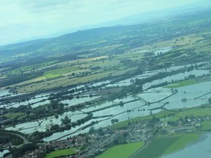
We were soon airborne. Dan was busy taking pictures of all the flooding in the local area, while I did a left turnout from runway 27 to set course direct to the BNN VOR and through Brize airspace.
I requested and got transit through Brize with a controller who was very interested that we were heading for Koblenz. He said he was posted there for a few years and were we going for the ‘Rhine on fire’ festival? I confess I had never heard of this and said no. He said it was on about now, so we may have struck it lucky.
I levelled out at 2700’ – no point in going any higher as we would only have to descend again to below 2500’ to stay under the London TMA. My attention wandered and I climbed a further 200’. Just as I was about to correct, a PA28 passed diagonally underneath us about 200’ below! No, probably neither of us saw each other.
We watched carefully to the north east for the NOTAM’d glider competition at Bicester. We spotted on which was no conflict. Clear of Brize zone, I changed to London Information on 126.40. They were very quiet indeed for a Saturday. Got FIS and ran the low level ‘corridor’ to the north of London under the TMA at 2400’. I stayed with London Info for the short channel crossing from Dover to Calais, but climbed to 4000’ for the crossing. The weather was good with few clouds and good visibility over the channel.
At the FIR, I changed to Lille Info on 120.27 and stayed with them until near the Belgian border. Around the coast at Calais, I had to descend to 2200’ to remain VMC, but as is common, once further inland, this lifted and I was able to climb to 3000’.
Changed to Brussels Info on 126.90. I heard him, but he said I was unreadable, so I should remain clear of controlled airspace. I wasn’t due to go near any for a while yet, so stayed on listening watch for now. I tried again later and was reported as strength 3, but still no FIS. I finally got through to him near the town of Kortrijk at 3700’ with category C airspace 15 nm ahead starting at 3500’. I asked for transit and he replied ‘you remain clear of controlled airspace unless you have approval for transit’ in his best petulant ‘I am a controller - what does this idiot think he is doing’ tone of voice!
I said that I knew that and that is why I was requesting transit! He responded with a terse ‘you call Brussels Approach on XXX.XX’. I don’t often come across unhelpful ground stations, but this guy was a real pl*nker! I was not sorry to switch.
In contrast, Brussels Approach were relaxed and very helpful. I got transit approval at 3900’ and was also advised that Beauvechain was closed, so no transit was required for them.
Once clear of their airspace, I switched to Liege Approach on 119.27 and got immediate transit approval through their airspace to the south on a direct track from HUL to SPI VOR’s.
The landscape changed from carefully tended fields to large forested areas – so we were in the Belgian Ardennes – scene of the famous ‘Battle of the Bulge’ from WW2. I knew this was rugged terrain from the road-trip we took last year. I spotted the Spa airfield easily and decided to follow the road to the infamous town of Malmedy.
I changed to Langen Info on 123.52 and crossed into German airspace for the first time. They were great and warned me about an active danger area and gave me vectors to avoid – ooops! That’ll teach me to take unscheduled detours!
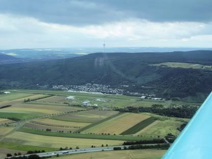
Then, it was a straight and easy run into Koblenz. It took a while for either of us to spot the airfield as we were approaching it from ‘the back’. I got it at 5 miles.
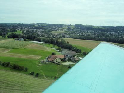
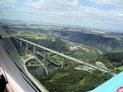
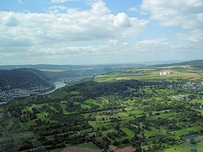
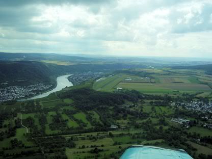
Joined downwind for runway 24 with right hand circuits. I was a bit close in. I turned base and saw the amazing sight of Koblenz in the valley that dropped sharply away from the airfield – so this is the ‘aircraft carrier’ airfield I had read so much about – a good analogy, except of course, there was plenty of tarmac!
I was so carried away by the view and misjudged the strong crosswind, that by the time I checked again, I had badly over-cooked the base leg and cranked the plane around hard to regain a sensible final approach track. I really should have gone around, but thought it might be fun to rescue it instead. The crosswind was something, it must have been a full 20 kts – given that, it was a reasonable crosswind landing.
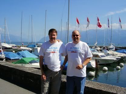
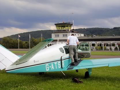
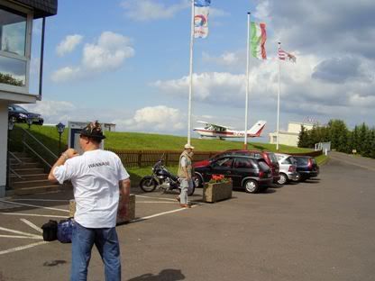
I taxied in and parked up on the grass. We unloaded, locked up and put the cover on the plane. Dan and I then walked past some onlookers outside the tower who stared in disbelief at our ‘team t-shirts’ complete with Bavarian green hunting hats festooned with badges (yes, we really did wear these during the trip and out on the streets – more of this later). Have these people no sense of style or taste?
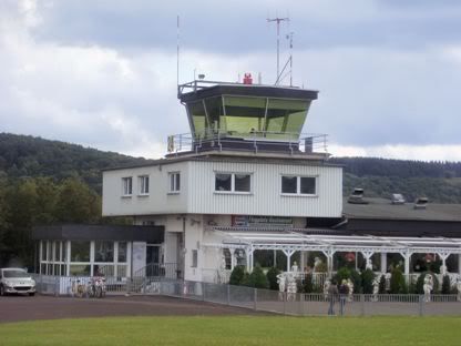
I went up to report to the tower and the guy up there was fantastic and very helpful indeed and suggested I pay on departure. He closed the flight plan and called a taxi.
As this is a flying blog and not a travelog, I won’t say much about Koblenz, except that we stayed in the Accor Ibis in the centre of Koblenz. The Accor hotels are a pilots dream as you can book on-line and cancel the same day either on-line or by phone, making them ideal for pilots who get weathered in (as I was to find out later).
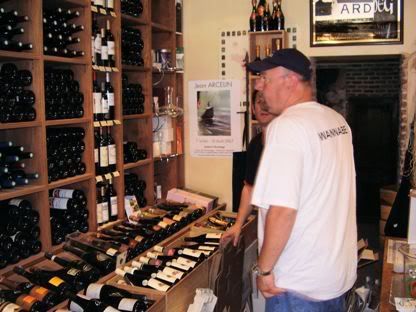
Koblenz itself was great and it is a bustling, working town. The ‘Rhine on fire’ wasn’t for two weeks yet, so we would miss that. We saw pretty much all the sights you could see on foot and enjoyed the fine food and especially the local wine and beer!
So, my first trip in a small plane to Germany and it was pretty easy. Belgian airspace can look intimidating, but once past the tw*t on Brussels Info, transits were easy to get. German airspace was very easy and Langen Info very professional and helpful.
Koblenz is a very scenic airfield and has a spectacular approach that make it very well worth visiting – just watch out for that crosswind!
The costs at Koblenz? Landing fee EUR 24.00, 3 days parking EUR 17.55 – while not ‘dirt cheap’ French prices, certainly pretty reasonable. Fuel was a bit more expensive than in the UK though.
EGBJ DCT BNN DCT LAM DCT DVR DCT MK DCT HUL DCT SPI DCT EDRK
So, this was the start of the ‘big trip’ for 2007. My buddy, Dan had arrived from Canada the previous week and seen a number of friends around the local area of Gloucester (yes, during the floods)! So we were both a bit relieved to be leaving the Gloucester area on a flying holiday – at least we could have more than a facecloth wash every night!
We rocked up at Gloucester airport on Saturday 29th July at about 10:30. I filed the flight plan with the reception desk (having filed the GAR the previous day). We unloaded and Dan carried the two 15l collapsible plastic camping containers full of precious water to act as ballast in the baggage compartment to counter-balance us two hefty guys in the front and keep us within the balance graph.
We loaded up and I taxied out to the pumps. As I was filling up, a rather nice looking Piper Meridien pulled up behind us and it was a fellow ‘Flyer Forumite’ Steven in his flashy mini-airliner – very nice too! We filled up and pulled forward so Steven could pull in behind and fill up while we faffed around.
We were soon airborne. Dan was busy taking pictures of all the flooding in the local area, while I did a left turnout from runway 27 to set course direct to the BNN VOR and through Brize airspace.
I requested and got transit through Brize with a controller who was very interested that we were heading for Koblenz. He said he was posted there for a few years and were we going for the ‘Rhine on fire’ festival? I confess I had never heard of this and said no. He said it was on about now, so we may have struck it lucky.
I levelled out at 2700’ – no point in going any higher as we would only have to descend again to below 2500’ to stay under the London TMA. My attention wandered and I climbed a further 200’. Just as I was about to correct, a PA28 passed diagonally underneath us about 200’ below! No, probably neither of us saw each other.
We watched carefully to the north east for the NOTAM’d glider competition at Bicester. We spotted on which was no conflict. Clear of Brize zone, I changed to London Information on 126.40. They were very quiet indeed for a Saturday. Got FIS and ran the low level ‘corridor’ to the north of London under the TMA at 2400’. I stayed with London Info for the short channel crossing from Dover to Calais, but climbed to 4000’ for the crossing. The weather was good with few clouds and good visibility over the channel.
At the FIR, I changed to Lille Info on 120.27 and stayed with them until near the Belgian border. Around the coast at Calais, I had to descend to 2200’ to remain VMC, but as is common, once further inland, this lifted and I was able to climb to 3000’.
Changed to Brussels Info on 126.90. I heard him, but he said I was unreadable, so I should remain clear of controlled airspace. I wasn’t due to go near any for a while yet, so stayed on listening watch for now. I tried again later and was reported as strength 3, but still no FIS. I finally got through to him near the town of Kortrijk at 3700’ with category C airspace 15 nm ahead starting at 3500’. I asked for transit and he replied ‘you remain clear of controlled airspace unless you have approval for transit’ in his best petulant ‘I am a controller - what does this idiot think he is doing’ tone of voice!
I said that I knew that and that is why I was requesting transit! He responded with a terse ‘you call Brussels Approach on XXX.XX’. I don’t often come across unhelpful ground stations, but this guy was a real pl*nker! I was not sorry to switch.
In contrast, Brussels Approach were relaxed and very helpful. I got transit approval at 3900’ and was also advised that Beauvechain was closed, so no transit was required for them.
Once clear of their airspace, I switched to Liege Approach on 119.27 and got immediate transit approval through their airspace to the south on a direct track from HUL to SPI VOR’s.
The landscape changed from carefully tended fields to large forested areas – so we were in the Belgian Ardennes – scene of the famous ‘Battle of the Bulge’ from WW2. I knew this was rugged terrain from the road-trip we took last year. I spotted the Spa airfield easily and decided to follow the road to the infamous town of Malmedy.
I changed to Langen Info on 123.52 and crossed into German airspace for the first time. They were great and warned me about an active danger area and gave me vectors to avoid – ooops! That’ll teach me to take unscheduled detours!
Then, it was a straight and easy run into Koblenz. It took a while for either of us to spot the airfield as we were approaching it from ‘the back’. I got it at 5 miles.
Joined downwind for runway 24 with right hand circuits. I was a bit close in. I turned base and saw the amazing sight of Koblenz in the valley that dropped sharply away from the airfield – so this is the ‘aircraft carrier’ airfield I had read so much about – a good analogy, except of course, there was plenty of tarmac!
I was so carried away by the view and misjudged the strong crosswind, that by the time I checked again, I had badly over-cooked the base leg and cranked the plane around hard to regain a sensible final approach track. I really should have gone around, but thought it might be fun to rescue it instead. The crosswind was something, it must have been a full 20 kts – given that, it was a reasonable crosswind landing.
I taxied in and parked up on the grass. We unloaded, locked up and put the cover on the plane. Dan and I then walked past some onlookers outside the tower who stared in disbelief at our ‘team t-shirts’ complete with Bavarian green hunting hats festooned with badges (yes, we really did wear these during the trip and out on the streets – more of this later). Have these people no sense of style or taste?
I went up to report to the tower and the guy up there was fantastic and very helpful indeed and suggested I pay on departure. He closed the flight plan and called a taxi.
As this is a flying blog and not a travelog, I won’t say much about Koblenz, except that we stayed in the Accor Ibis in the centre of Koblenz. The Accor hotels are a pilots dream as you can book on-line and cancel the same day either on-line or by phone, making them ideal for pilots who get weathered in (as I was to find out later).
Koblenz itself was great and it is a bustling, working town. The ‘Rhine on fire’ wasn’t for two weeks yet, so we would miss that. We saw pretty much all the sights you could see on foot and enjoyed the fine food and especially the local wine and beer!
So, my first trip in a small plane to Germany and it was pretty easy. Belgian airspace can look intimidating, but once past the tw*t on Brussels Info, transits were easy to get. German airspace was very easy and Langen Info very professional and helpful.
Koblenz is a very scenic airfield and has a spectacular approach that make it very well worth visiting – just watch out for that crosswind!
The costs at Koblenz? Landing fee EUR 24.00, 3 days parking EUR 17.55 – while not ‘dirt cheap’ French prices, certainly pretty reasonable. Fuel was a bit more expensive than in the UK though.
Subscribe to:
Posts (Atom)