Flying
BFR: San Antonio International to Fredericksburg and return
Solid IMC all the way with descents to minimums
2.9 Hours total as P U/T (2.0 IMC)
Leg 1: San Antonio International to Galveston
KSAT DCT VCT DCT PSX DCT KGLS
VFR on top and below scattered to broken cloud deck at 3500’
Flying along the scenic Gulf coast
2.4 Hours total
Leg 2: Galveston to Corpus Christi International
KGLS DCT CRP DCT KCRP
Flying in ‘Severe VFR’ along the scenic Gulf coast at 3000’
2.3 Hours total
Leg 3: Corpus Christi International to San Antonio International
KCRP DCT CRP DCT THX DCT KSAT
Again, ‘Severe VFR’ to the north west at 4500’
1.8 Hours total
Total costs:
BFR aircraft hire and instructor sign off: $240
Aircraft hire (wet) for all three legs: $850
Highlights
Refreshing IMC skills
Lunch in the airport diner at Fredericksburg
Playing with the clouds around the gulf coast
Flying along the scenic gulf coast
The un-crowded skies
Lowlights
Waiting 40 minutes for IFR departure clearance at Fredericksburg
Any time spent in the plane while not flying (you cook very quickly!)
Dan busting my camera
Putting on weight
….errrr…..
What I like about flying in the USA
1-800-WX-BRIEF
Flight Following
Relaxed radio manner
Fantastic service from FBO’s
Vast array of information and services available on the radio
What I don’t like about flying in the USA
….errrrr……
Thursday, October 22, 2009
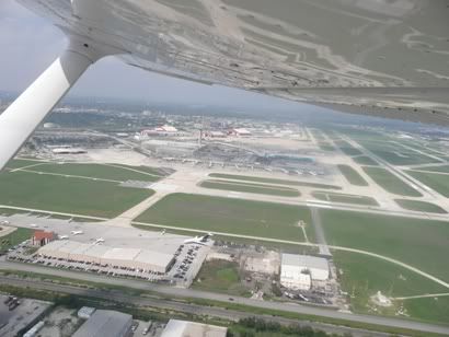
Corpus Christi to San Antonio
The Signature FBO premises at Corpus Christi were excellent and spacious. There was a plush reception and front desk, a separate snack and free coffee area, toilets and a shower and a flight planning room with lots of table space, not to mention a few meeting rooms. I asked about their handling charges and they were all free with the fuel upload that I had to take anyway – wow!
So Dan tore off in the courtesy car in search of Burger King, while I got on with route planning in the planning room. This would have been considerably easier if it were not for two ‘military types’ chewing the fat very loudly and relating tales of derring-do. I think I made my point by theatrically putting one finger in my free ear and looking at them while try to talk to the wonderful 1-800-WX BRIEF – guys, there is a whole empty reception and coffee room for lounging around in, why pick here!
The plan was easy as it turned out:
KCRP DCT CRP DCT THX DCT KSAT
So a short hop to the Corpus Christi VOR, then north west to the THX VOR then nearly due north to San Antonio International. I finished my planning, sorted the bill (none as it went on the school fuel card) and got myself together for a bit of a think before Dan reappeared with two ‘Whoppers’ for our grumbling bellies with some tale of extreme navigation without so much as a Tom Tom. We demolished these in short order and as per Homeland Security, had to show both a photo proof of id and my pilot licence before I would be admitted airside.
The plane was full to the brim (that’s the way I like it if I can fit within weight and balance), so a quick check of fuel and oil and we mounted up. Then the usual procedure of calling Clearance to get our taxi and likely routing after take off. We trundled off to the hold for runway 17 quickly getting very sweaty again in the very high heat and humidity. The airport was pretty quiet and we were quickly given clearance for take off by the Tower after our power checks. It was a climbing left turnout onto direct track for CRP VOR as we were switched to the Departure frequency. I turned on track to THX VOR some 51 miles distant as we reached our VFR cruising altitude of 4500’ in what can only be described as ‘severe VFR’ conditions – no clouds and unlimited visibility!
I was receiving the effortless ‘flight following’ when I was warned of traffic at 12 o’clock and 500’ below. We never did see him (not even dead-eye-Dan), but he clearly saw us and confirmed ‘no conflict’ – phew!
Not much to say really, we trundled along chatting happily away. Past THX VOR we were transferred to San Antonio approach, then with about 30 miles to run they started to give us vector to steer while maintaining 4500’. I have not been vectored before while flying VFR (I have been vectored before for an ILS intercept in IMC of course). I have to say it was quite novel and liberating. Dan compared it to being in a Star Trek style ‘tractor beam’ – errr… well, yes, but only if you actually steer accurately the headings given, actually a flattering analogy I suppose!
He kept us at 4500’ despite an approaching cloud layer over San Antonio at exactly this altitude, but then the controller seemed aware of that and promised to drop our altitude shortly. We were being vectored over the west of the city centre and descended first to 3000’ then to 2500’ on the QNH (San Antonio is about 800’ above sea level). Over the city centre it occurred to me that this would be a very bad place to have engine failure as there was nowhere to go that would make our survival a likely outcome!
He then gave me a heading of 030 and told me to report overhead ---MUFFLED---, I didn’t quite understand the name and as I now had the airfield off on my right-hand side with large jets landing, I told him that I was unfamiliar with the reporting point and requested further vectors. Another voice seemed to have taken over the Tower frequency and he explained what they wanted me to do, basically now I was right downwind to the main runway, they were asking me to turn right 90 degrees at 2500’ so that I would fly directly overhead the tower at right angles to the two main parallel runways, then to turn left onto a left downwind leg for runway 12L – what an excellent chap, I now fully understood what they were doing and had a picture. Of course to a UK pilot, the idea of flying over a busy International airport’s main runway at right angles at 1700’ QFE is mind-boggling (I don’t know of any airports in the UK that would do this), but it is quite common in the USA and when you think about it, it is pretty much the safest place to be. There was a really cool moment when I was flying over the main 12R runway and a very colourful South West Airline 737 was taking off underneath us – of course I would have got a photo of the had it not been for old ‘Zoltan the Destroyer of Cameras’ in the right hand seat!
So over the airliner active of 12R, out to a decent downwind position for 12L then turn left onto left downwind. The route for the base was obvious, just follow the freeway. I heard the tower talking to an airliner who was shooting the final onto 12R at the same time as I was on base for 12L warning him about me. I turned at the right point onto final for 12L and was (as usual on this trip) a little high, so full flaps and down to idle. That took care of it and we crossed the threshold at the right speed for a good touchdown. Off the active to the GA side of the airport now on my left and switched to the Ground frequency. Basically it was an easy task to taxi back to the Wright Flyers ramp for shutdown and tie-down.
We got out of the aircraft as quickly as possible as we were sweating profusely in the bright sunshine and humid conditions. An easy final leg to a truncated tour, but well worth it nevertheless. The forecast CB’s and other nasties associated with a front had not materialised at San Antonio, but suffice to say that two hours later at our hotel, some nasty looking clouds came over and created some pretty high and gusting winds, but little else.
Galveston to Corpus Christi
After an evening of cocktails and finger food at the pool bar at the San Luis in Galveston, the plan was to use this, the last planned day of my truncated flying trip to see the gulf coast then head back to San Antonio. The problem was that I didn’t have the 1-50,000 sectional for Brownsville, so I couldn’t go any further south than I had come the day before. Wright Flyers didn’t have a map and Galveston didn’t either. Except that the guy who drove us to the hotel yesterday heard me talking about this and said that he could probably get me one if I needed it. I confirmed that I did and he said ‘no problem’.
What I didn’t realise is that he drove to mainland to another supplier that afternoon specially to get me one – these guys amaze me!
So I now had a Brownsville sectional and could see the lay of the land. I checked the weather and the wonderful 1-800-WX BRIEF told me that a front was moving in faster than they thought to San Antonio and may well start to make its presence felt by late afternoon. So I decided to do a ‘slash and dash’ to an airfield along the coast just to say I had been there, then head to San Antonio – pretty much two sides of a triangle. The wind was about 180/15, so I would be beating into the wind in a Cessna that does, say 105kts. I wanted to try for Brownsville on the Mexican border, but decided instead to go to Corpus Christi International – great name for a town, so might be worth a look. My ‘route’ such as it was:
KGLS DCT CRP DCT KCRP (Coastwise)
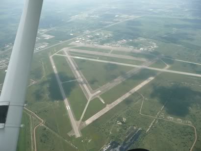
I planned my route, got the NOTAM’s (none) and filed a flight plan. I took advantage of local knowledge and asked the guy at the FBO about the route and in particular a warning area that involved low-level military jet training. He said it wasn’t a particular problem as long as I had flight following I would be fine. The way he described it made is sound like a UK the Brize area, so I decided to go through the area. I got the plates for Corpus Christi International and it was BIG. Depending on the runway, navigating the taxiways could be interesting, so I vowed to ask for progressive taxi instructions if I was at all uncertain. I tried to plan the route, but it was far too simple really – follow the coast, then when you see the urban build-up around Corpus Christi, track direct to the CRP VOR then head south over the estuary to the airport.
I asked the lady at the FBO for the bill for the handling fee. I had already given them the fuel card I got from Wright Flyers, so that was taken care of. She looked puzzled and said they had taped a copy of the bill to the plane already. I looked confused and said that surely I had to pay for handling, like landing fees, handling, etc. She said that no, there was nothing to pay and that they were happy to have my custom in buying the fuel. Well there is the difference between the USA and the UK right there. I couldn’t let it rest at that, so I paid $20 to their Christmas drinks fund.
We wandered out onto the sweltering ramp in about 95 degrees and 95% humidity, but at least with a fair old breeze coming from the south. Dan cleared all the tie downs and checked the fuel and oil as I started the walkaround. The plane was fine and I loaded up, leaving the actual climbing in as late as I could coz we would cook! The place was again deserted of airside movements as I called the tower for taxi. We were given runway 17. I did the run up checks and was immediately cleared for take off. Another plane called for landing and was given clearance to land, but told that I was lining up. This seems to be common practice in the USA, to clear two planes to either land or one to take off and one to land at the same time – well not actually the same time, but you get the point. So I called both lining up and rolling just to give the landing pilot the idea where I was.
Up we went as I set a climbing turn onto a coastwise heading of about 150. We climbed to 3000’ and held steady there as I contacted Houston Center for flight following, which we got, set the squawk and settled down to admire the view. The weather was ‘Severe VFR’ – not a cloud in the sky, other than a few as you looked inland. Well, I would love to have loads of excellent pictures of the fantastic landforms along the coast, but my buddy fumbled my camera (the truly excellent Panasonic Lumix compact) last night after he took a picture and it hit the concrete right on the corner of the lens which distorted the telescoping rings of the lens such that it would no longer open – so hey, no more photos this trip – I know he feels bad about it, but hell, it was my favourite camera of all time, and it's not so much the camera as the photos we didn't take – still there is a replacement on the way. Dan – you gotta get your own camera buddy (think ruggedised military model)!
We were taking a bit of a beating and the headwind was slowing our groundspeed down to 80kts, but no hurry in particular. We enjoyed the view as the landmarks came and went. A disused airfield here, an in use one there, a huge disused military airfield etc.
As I reached the turn point to head inland a bit, we were handed over to Corpus Christi Approach. They warned us of a T38 military trainer some five miles from us at 11 o’clock but at 2500’. I think he must have been in contact with said trainer as he suggested a new heading (which we quickly and eagerly accepted!) which would keep us away from the manoeuvring jet! We beat out way towards the CRP VOR over some very, very colourful tracts of water that look alternately like a dreadful biological experiment gone-wrong and the salt pans of Mediterranean France (no photos as no camera).
Once over CRP I headed directly for the airfield and we spotted it pretty quickly. I called airfield in sight and was transferred from Approach to Tower. They gave me an immediate ‘clear to land’ on runway 17, which I was pretty much on very extended final for already. I continued and start a cruise descent as I didn’t want to hang around on final for the active at an international airport for too long, despite the fact that there were evident not very busy.
Well I misjudged it a little and left myself high on final, so I dropped full flap and gave it a gentle side-slip. This did the trick as we cruised over the piano keys at 65kts. Flare, hold off and off and down we touch. Nice one. I have no idea where I should go and as if reading my thought they ask ‘where would you like to go’ I respond ‘unfamiliar with airport, can you suggest an FBO?’. I get ‘uhh yeah, probably Signature, whaddaya think?’. Well, I had heard of them from others who have flown in the USA, they are a GA flight handling service with bases at many US airport, so I said that would be fine and asked for progressive taxi instructions.
‘Yeah sure, turn left up ahead then hang a right towards the mess of buildings ahead’. OK, fine with that, then I got ‘Yah see that hangar up ahead with the funky roof?’ looking, oh yeah, so I reply in mock formal aviation parlance ‘Zero Sierra Alpha: affirm visual with funky roof’, ‘well, that’s signature, head on over there – now you have a great day!’ – America – God I love this place!
So I mosey on over to the funky rook and park up where it looks like I should, outside a building marked ‘Signature’. A refueller stops what he is doing and marshalls me in. I shut down and he immediately asks ‘How y’all doin fer gas?’ so I gave him the ‘top it off there buddy’ response with a jerk of my thumb toward said aircraft which appears to mean ‘full tanks both side if you would be so kind my man’ he seemed satisfied with my response and started to refuel pretty much as we headed for Signature!
More air-conditioned bliss, but this time, a much busier FBO, with several pilots in various states of preparedness and various garbs from T-shirt and shorts (me) to full pressed trousers, peaked cap and a full set of ‘wanker bars’ (warranted though as he seemed to be a commercial pilot flying a Citation).
Dan looked haggard and emaciated and immediately asked about food. The bad news was vending machines only, but hey, there was a Burger King on the highway. He asked how far to walk ‘Oh you kaint waaalk, but herezuh kees fer du car, yall can drive – sonly faave minuts’ (OK I’m exaggerating a bit, but not much!). Dan set about the foraging while I set about planning for the final leg back to San Antonio.
What I didn’t realise is that he drove to mainland to another supplier that afternoon specially to get me one – these guys amaze me!
So I now had a Brownsville sectional and could see the lay of the land. I checked the weather and the wonderful 1-800-WX BRIEF told me that a front was moving in faster than they thought to San Antonio and may well start to make its presence felt by late afternoon. So I decided to do a ‘slash and dash’ to an airfield along the coast just to say I had been there, then head to San Antonio – pretty much two sides of a triangle. The wind was about 180/15, so I would be beating into the wind in a Cessna that does, say 105kts. I wanted to try for Brownsville on the Mexican border, but decided instead to go to Corpus Christi International – great name for a town, so might be worth a look. My ‘route’ such as it was:
KGLS DCT CRP DCT KCRP (Coastwise)
I planned my route, got the NOTAM’s (none) and filed a flight plan. I took advantage of local knowledge and asked the guy at the FBO about the route and in particular a warning area that involved low-level military jet training. He said it wasn’t a particular problem as long as I had flight following I would be fine. The way he described it made is sound like a UK the Brize area, so I decided to go through the area. I got the plates for Corpus Christi International and it was BIG. Depending on the runway, navigating the taxiways could be interesting, so I vowed to ask for progressive taxi instructions if I was at all uncertain. I tried to plan the route, but it was far too simple really – follow the coast, then when you see the urban build-up around Corpus Christi, track direct to the CRP VOR then head south over the estuary to the airport.
I asked the lady at the FBO for the bill for the handling fee. I had already given them the fuel card I got from Wright Flyers, so that was taken care of. She looked puzzled and said they had taped a copy of the bill to the plane already. I looked confused and said that surely I had to pay for handling, like landing fees, handling, etc. She said that no, there was nothing to pay and that they were happy to have my custom in buying the fuel. Well there is the difference between the USA and the UK right there. I couldn’t let it rest at that, so I paid $20 to their Christmas drinks fund.
We wandered out onto the sweltering ramp in about 95 degrees and 95% humidity, but at least with a fair old breeze coming from the south. Dan cleared all the tie downs and checked the fuel and oil as I started the walkaround. The plane was fine and I loaded up, leaving the actual climbing in as late as I could coz we would cook! The place was again deserted of airside movements as I called the tower for taxi. We were given runway 17. I did the run up checks and was immediately cleared for take off. Another plane called for landing and was given clearance to land, but told that I was lining up. This seems to be common practice in the USA, to clear two planes to either land or one to take off and one to land at the same time – well not actually the same time, but you get the point. So I called both lining up and rolling just to give the landing pilot the idea where I was.
Up we went as I set a climbing turn onto a coastwise heading of about 150. We climbed to 3000’ and held steady there as I contacted Houston Center for flight following, which we got, set the squawk and settled down to admire the view. The weather was ‘Severe VFR’ – not a cloud in the sky, other than a few as you looked inland. Well, I would love to have loads of excellent pictures of the fantastic landforms along the coast, but my buddy fumbled my camera (the truly excellent Panasonic Lumix compact) last night after he took a picture and it hit the concrete right on the corner of the lens which distorted the telescoping rings of the lens such that it would no longer open – so hey, no more photos this trip – I know he feels bad about it, but hell, it was my favourite camera of all time, and it's not so much the camera as the photos we didn't take – still there is a replacement on the way. Dan – you gotta get your own camera buddy (think ruggedised military model)!
We were taking a bit of a beating and the headwind was slowing our groundspeed down to 80kts, but no hurry in particular. We enjoyed the view as the landmarks came and went. A disused airfield here, an in use one there, a huge disused military airfield etc.
As I reached the turn point to head inland a bit, we were handed over to Corpus Christi Approach. They warned us of a T38 military trainer some five miles from us at 11 o’clock but at 2500’. I think he must have been in contact with said trainer as he suggested a new heading (which we quickly and eagerly accepted!) which would keep us away from the manoeuvring jet! We beat out way towards the CRP VOR over some very, very colourful tracts of water that look alternately like a dreadful biological experiment gone-wrong and the salt pans of Mediterranean France (no photos as no camera).
Once over CRP I headed directly for the airfield and we spotted it pretty quickly. I called airfield in sight and was transferred from Approach to Tower. They gave me an immediate ‘clear to land’ on runway 17, which I was pretty much on very extended final for already. I continued and start a cruise descent as I didn’t want to hang around on final for the active at an international airport for too long, despite the fact that there were evident not very busy.
Well I misjudged it a little and left myself high on final, so I dropped full flap and gave it a gentle side-slip. This did the trick as we cruised over the piano keys at 65kts. Flare, hold off and off and down we touch. Nice one. I have no idea where I should go and as if reading my thought they ask ‘where would you like to go’ I respond ‘unfamiliar with airport, can you suggest an FBO?’. I get ‘uhh yeah, probably Signature, whaddaya think?’. Well, I had heard of them from others who have flown in the USA, they are a GA flight handling service with bases at many US airport, so I said that would be fine and asked for progressive taxi instructions.
‘Yeah sure, turn left up ahead then hang a right towards the mess of buildings ahead’. OK, fine with that, then I got ‘Yah see that hangar up ahead with the funky roof?’ looking, oh yeah, so I reply in mock formal aviation parlance ‘Zero Sierra Alpha: affirm visual with funky roof’, ‘well, that’s signature, head on over there – now you have a great day!’ – America – God I love this place!
So I mosey on over to the funky rook and park up where it looks like I should, outside a building marked ‘Signature’. A refueller stops what he is doing and marshalls me in. I shut down and he immediately asks ‘How y’all doin fer gas?’ so I gave him the ‘top it off there buddy’ response with a jerk of my thumb toward said aircraft which appears to mean ‘full tanks both side if you would be so kind my man’ he seemed satisfied with my response and started to refuel pretty much as we headed for Signature!
More air-conditioned bliss, but this time, a much busier FBO, with several pilots in various states of preparedness and various garbs from T-shirt and shorts (me) to full pressed trousers, peaked cap and a full set of ‘wanker bars’ (warranted though as he seemed to be a commercial pilot flying a Citation).
Dan looked haggard and emaciated and immediately asked about food. The bad news was vending machines only, but hey, there was a Burger King on the highway. He asked how far to walk ‘Oh you kaint waaalk, but herezuh kees fer du car, yall can drive – sonly faave minuts’ (OK I’m exaggerating a bit, but not much!). Dan set about the foraging while I set about planning for the final leg back to San Antonio.
San Antonio to Galveston
Of course the front didn’t clear did it!? So on our planned departure date of Tuesday (we had the plane booked for three days of touring) I checked the weather, looked out of the window and easily decided it was a no-go. It was raining with a cloudbase that you simply couldn’t see as it was that indistinct and low – that, coupled with a forecast of embedded CB’s, meant that the decision not to fly was a no-brainer. I called Wright Flyers and advised them that as I was VFR touring, I would cancel the plane for today, but would retain my booking for the following two days hoping that the weather would improve (as it was forecast to do). So instead, that day, we drove to Austin to see the city instead.
Wednesday morning dawned much brighter with some clear bits in Austin as the cloud broke and lifted. The forecast was good, so we headed back the 60 or so miles to San Antonio. When we got to Wright Flyers, I got a blank look from the lady on reception and she said that my booking for all the three days had been cancelled. I said that I specifically spoke to the lady on duty yesterday and that she assured me that she was only cancelling one day. Then of course the ‘do you remember who you spoke to’ bit – I thought ‘Oh God, here we go’. Then one of the Wright Flyers senior guys that I met yesterday came up and asked me if everything was OK. I explained the situation and he simply smiled and said ‘Hey, no problems, we can fix this’. I overheard him say to the lady on reception ‘Make it happen’ as she set about clearing the plane of bookings. Screw-ups do happen, but it is how they are dealt with that makes the difference and I have to say Wright Flyers did very well in that regard – thanks guys!
While she was clearing the plane, I set about deciding where we could go bearing in mind the weather and route planning. The weather was worse further north, so back to Plan A and head east to the gulf coast and Galveston, which seems to be a nice island which also has an aircraft museum on-airport. I decided on a route that would avoid the Houston Class B airspace and so would swing a little south and allow us to fly up the interesting looking coast and inter coastal waterways, which I was told was pretty scenic. So my route was:
KSAT DCT VCT DCT PSX DCT KGLS
I estimated it would be some 200 nautical miles and take about 2:20 hours. Of course I would make life easy on myself and hop from VOR to VOR, easy to plot on the GPS and easy to follow on the VOR in the plane as a check and if the GPS reception failed. I had brought my old hand-held Garmin GPS Pilot 3, with it’s tiny screen, but it is easy to use. Of course I didn’t have the US database, so had to hand-crank the airports and VOR locations, so careful and easy does it, don’t want to get a wrong lat/long! I got a full weather brief, NOTAM’s and filed a flight plan through the absolutely excellent 1-800-WX BRIEF phone service – WHAT A FANTASTIC SERVICE THIS IS! This, ‘Flight Following’ and fantastic and usually free handling from many FBO’s make flying in the USA a real joy (not to mention the scenery).
I had to complete a risk assessment sheet and a worksheet including weight and balance so that they could formally sign me out in the plane – very thorough of them. This I did as they escorted me out to the apron (I had no US FAA Id card, so an escort is mandatory now with the Homeland Security restrictions, especially as this was an international airport). The cloud was breaking nicely, with the cloudbase probably at about 2500’ and the tops at 4000’. Boy was it HOT though! The temperature was about 90 degrees and the humidity at least 95% - fairly normal for Texas I am told! I had the plane filled to the brim, which would take the overall weight nicely up to MAUW with myself and Dan (neither of us are particularly small or slight guys). I positioned everything and put the water in the ubiquitous cup holders then waited a few minutes for my flight plan departure time. We climbed in and closed the doors and opened the windows, but even so, we started to bake!
I called ‘Clearance’ as required and got taxi instructions for 12L as expected. I stayed with them until I completed the power checks and was ready to depart when they handed me off to the Tower. Mercifully, they quickly gave me a ‘clear for take-off’ as we were really sweating by now – I would not even like to think what an RV6 with it’s bubble canopy would be like over here! I powered up and took off. The tower started to vector me in the climb, then handed me over to ‘Departures’. I asked for and got the wonderfully ‘Flight Following’ service. For anyone who hasn’t flown in the UK, this is the sort of service you get from, say Farnborough Radar where they give you a squawk and provide traffic information when they can, but the real bonus is that they will automatically hand you over en-route, so all you have to do is change to the frequency they tell you, contact the new ‘Center’ giving them your callsign and that’s it! Often you keep the same squawk – wonderful!
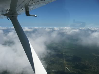
I climbed to 2000’ as that was all I was going to get for now. I was tempted to climb up through the broken cloud as the tops were only at probably 3500’ (which is the altitude I wanted as in the USA when flying VFR, you should fly at ‘odd plus 500’ going east and ‘even plus 500’ going west), but I decided to hold off for now as I didn’t want to get ‘stuck’ on-top and shoot an unfamiliar approach. However, as we approached Victoria, the cloud broke even more and started to lift. So I climbed to 2500’ then decided to climb on-top, which I got to at 3500’. By now the clouds were starting to spread out even more and became ‘scattered’.
Flying overhead Victoria was a strange sensation. We were above their airspace so they weren’t worried about us, but what a huge airfield! We could see a Citation doing circuits, but that was about all. If someone had told me that was an international airport, I would have believed them!
Past the Victoria VOR, we set course for the PSX VOR which would take us to within sight of the coast. As we closed in on this, the clouds got thicker and went back to broken and got deeper, so I could either climb or go back underneath. I chose to go back down and was clear at 2500’. But then as we approached the coast, the base dropped even more and forced us down to 1800’, but I could see that over the actual coast is was ‘Sky Clear’ as is often the case, so I was hardly concerned. I avoided a prohibited area that stated it was for a static line holding a balloon up to 15000’ (yes – fifteen thousand feet), what kind of balloon was that!!!
I was called by Houston Center who were providing me with flight following asking what I was doing on altitude. I said I was dodging a few clouds to stay VFR, whereupon they said with poor radar coverage at the altitude I was on my own and should squawk 1200 – goodbye! No problem, not far to run, so I changed to listening watch on Galveston ASOS (automated weather broadcast). But all it said over and over again was ‘This is Galveston ASOS’. So I guess it wasn’t working properly, so I switched to Galveston Tower and listened in.
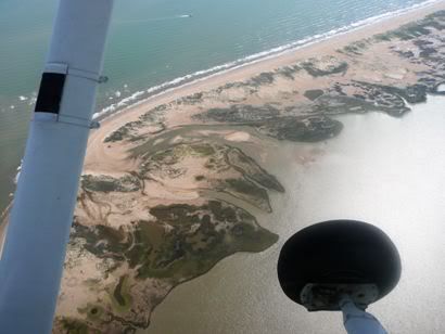
We hit the coast, which is not so much a coast as a mess of swamps, winding and tidal inter-coastal waterways and long, thin islands fronting the Gulf of Mexico. All of which made for some really great land and sea-scapes. We were completely clear of cloud, but as we didn’t have that far to run and were enjoying the view of the sea-scapes, I stayed at 2000’. The coast was devoid of any evidence of human habitation. This started to change as we got nearer to Galveston with the odd road, then some obviously planned developments with or without their own jetty onto a waterway.
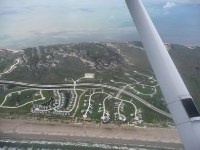
Once onto the very long (maybe 30 miles long) but thin (maybe 3 miles wide) Galveston Island, there were far more and some very classy residential developments. With 30 miles to run, I contacted Galveston tower for airfield information and joining. They were using runway 17 with right hand circuits and reporting the winds as 180 / 10-15. I was to join on the downwind leg. They were very quiet and I only heard two other aircraft on frequency as we approached, one helicopter and some sort of navy aircraft.
We spotted the airfield fairly easily with about 8 miles to run. The biggest of the runways has obviously recently been resurfaced in a very black tarmac, which showed up really well compared with the other runway and taxiways all in concrete the same colour as the sand. I joined into an empty pattern and was immediately cleared to land. We went out wide into the water between the mainland and the island and over the main bridge to the island. I settled on a good looking approach to runway 17. Flaps down and speed under control at 70kts with the target of 65 over the fence. This I did and flared nicely. Bit of a stall warning as we touched and I dealt with what felt like gusty conditions. We turned off and easily taxied to the ramp as the taxiways were not complex. I was about to park up when a guy driving a golf buggy and wearing shorts, a loud Hawaiian shirt, shorts and sandals marshalled us to a spot with tie downs – what a nice fellah!
We shutdown as quickly as we could and popped the doors and stumbled out, sweating profusely – all in the space of five minutes from touching down – damn it’s hot!
Well, it turns out that the airfield was badly flooded during Hurricane Ike in September 2008 which completely gutted the terminal and the aircraft museum. So the Galveston FBO were in some temporary huts. We were ushered in to air-conditioned bliss. Well, the FBO and the people here could not have been more friendly or helpful. They dished out bottled water, asked us what we wanted in fuel and within 5 minutes they were refuelling. They booked a hotel for us and later drove us both out there. This really is the best part of flying in the USA – wonderful!
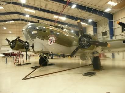
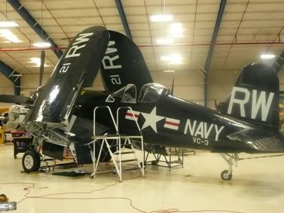
But first we went to the Lone Star aircraft museum. This is on the edge of the airfield, but you have to go out of the gate to get there. We got ferried over in the golf cart of course. For a few dollars entrance fee, we saw the planes. The unique thing about them is that virtually every single one is in flying condition and is regularly flown giving people warbird experiences. The B17 was positively pristine as was the Corsair. There is a Liberator undergoing complete refurbishment. What a great museum, seeing aircraft that still fly. I couldn’t resist as bright aircraft themed Hawaiian shirt though.
A nice flight and well worth the effort. Lovely gulf coast scenery and a great airport.
Wednesday morning dawned much brighter with some clear bits in Austin as the cloud broke and lifted. The forecast was good, so we headed back the 60 or so miles to San Antonio. When we got to Wright Flyers, I got a blank look from the lady on reception and she said that my booking for all the three days had been cancelled. I said that I specifically spoke to the lady on duty yesterday and that she assured me that she was only cancelling one day. Then of course the ‘do you remember who you spoke to’ bit – I thought ‘Oh God, here we go’. Then one of the Wright Flyers senior guys that I met yesterday came up and asked me if everything was OK. I explained the situation and he simply smiled and said ‘Hey, no problems, we can fix this’. I overheard him say to the lady on reception ‘Make it happen’ as she set about clearing the plane of bookings. Screw-ups do happen, but it is how they are dealt with that makes the difference and I have to say Wright Flyers did very well in that regard – thanks guys!
While she was clearing the plane, I set about deciding where we could go bearing in mind the weather and route planning. The weather was worse further north, so back to Plan A and head east to the gulf coast and Galveston, which seems to be a nice island which also has an aircraft museum on-airport. I decided on a route that would avoid the Houston Class B airspace and so would swing a little south and allow us to fly up the interesting looking coast and inter coastal waterways, which I was told was pretty scenic. So my route was:
KSAT DCT VCT DCT PSX DCT KGLS
I estimated it would be some 200 nautical miles and take about 2:20 hours. Of course I would make life easy on myself and hop from VOR to VOR, easy to plot on the GPS and easy to follow on the VOR in the plane as a check and if the GPS reception failed. I had brought my old hand-held Garmin GPS Pilot 3, with it’s tiny screen, but it is easy to use. Of course I didn’t have the US database, so had to hand-crank the airports and VOR locations, so careful and easy does it, don’t want to get a wrong lat/long! I got a full weather brief, NOTAM’s and filed a flight plan through the absolutely excellent 1-800-WX BRIEF phone service – WHAT A FANTASTIC SERVICE THIS IS! This, ‘Flight Following’ and fantastic and usually free handling from many FBO’s make flying in the USA a real joy (not to mention the scenery).
I had to complete a risk assessment sheet and a worksheet including weight and balance so that they could formally sign me out in the plane – very thorough of them. This I did as they escorted me out to the apron (I had no US FAA Id card, so an escort is mandatory now with the Homeland Security restrictions, especially as this was an international airport). The cloud was breaking nicely, with the cloudbase probably at about 2500’ and the tops at 4000’. Boy was it HOT though! The temperature was about 90 degrees and the humidity at least 95% - fairly normal for Texas I am told! I had the plane filled to the brim, which would take the overall weight nicely up to MAUW with myself and Dan (neither of us are particularly small or slight guys). I positioned everything and put the water in the ubiquitous cup holders then waited a few minutes for my flight plan departure time. We climbed in and closed the doors and opened the windows, but even so, we started to bake!
I called ‘Clearance’ as required and got taxi instructions for 12L as expected. I stayed with them until I completed the power checks and was ready to depart when they handed me off to the Tower. Mercifully, they quickly gave me a ‘clear for take-off’ as we were really sweating by now – I would not even like to think what an RV6 with it’s bubble canopy would be like over here! I powered up and took off. The tower started to vector me in the climb, then handed me over to ‘Departures’. I asked for and got the wonderfully ‘Flight Following’ service. For anyone who hasn’t flown in the UK, this is the sort of service you get from, say Farnborough Radar where they give you a squawk and provide traffic information when they can, but the real bonus is that they will automatically hand you over en-route, so all you have to do is change to the frequency they tell you, contact the new ‘Center’ giving them your callsign and that’s it! Often you keep the same squawk – wonderful!
I climbed to 2000’ as that was all I was going to get for now. I was tempted to climb up through the broken cloud as the tops were only at probably 3500’ (which is the altitude I wanted as in the USA when flying VFR, you should fly at ‘odd plus 500’ going east and ‘even plus 500’ going west), but I decided to hold off for now as I didn’t want to get ‘stuck’ on-top and shoot an unfamiliar approach. However, as we approached Victoria, the cloud broke even more and started to lift. So I climbed to 2500’ then decided to climb on-top, which I got to at 3500’. By now the clouds were starting to spread out even more and became ‘scattered’.
Flying overhead Victoria was a strange sensation. We were above their airspace so they weren’t worried about us, but what a huge airfield! We could see a Citation doing circuits, but that was about all. If someone had told me that was an international airport, I would have believed them!
Past the Victoria VOR, we set course for the PSX VOR which would take us to within sight of the coast. As we closed in on this, the clouds got thicker and went back to broken and got deeper, so I could either climb or go back underneath. I chose to go back down and was clear at 2500’. But then as we approached the coast, the base dropped even more and forced us down to 1800’, but I could see that over the actual coast is was ‘Sky Clear’ as is often the case, so I was hardly concerned. I avoided a prohibited area that stated it was for a static line holding a balloon up to 15000’ (yes – fifteen thousand feet), what kind of balloon was that!!!
I was called by Houston Center who were providing me with flight following asking what I was doing on altitude. I said I was dodging a few clouds to stay VFR, whereupon they said with poor radar coverage at the altitude I was on my own and should squawk 1200 – goodbye! No problem, not far to run, so I changed to listening watch on Galveston ASOS (automated weather broadcast). But all it said over and over again was ‘This is Galveston ASOS’. So I guess it wasn’t working properly, so I switched to Galveston Tower and listened in.
We hit the coast, which is not so much a coast as a mess of swamps, winding and tidal inter-coastal waterways and long, thin islands fronting the Gulf of Mexico. All of which made for some really great land and sea-scapes. We were completely clear of cloud, but as we didn’t have that far to run and were enjoying the view of the sea-scapes, I stayed at 2000’. The coast was devoid of any evidence of human habitation. This started to change as we got nearer to Galveston with the odd road, then some obviously planned developments with or without their own jetty onto a waterway.
Once onto the very long (maybe 30 miles long) but thin (maybe 3 miles wide) Galveston Island, there were far more and some very classy residential developments. With 30 miles to run, I contacted Galveston tower for airfield information and joining. They were using runway 17 with right hand circuits and reporting the winds as 180 / 10-15. I was to join on the downwind leg. They were very quiet and I only heard two other aircraft on frequency as we approached, one helicopter and some sort of navy aircraft.
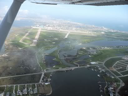
We spotted the airfield fairly easily with about 8 miles to run. The biggest of the runways has obviously recently been resurfaced in a very black tarmac, which showed up really well compared with the other runway and taxiways all in concrete the same colour as the sand. I joined into an empty pattern and was immediately cleared to land. We went out wide into the water between the mainland and the island and over the main bridge to the island. I settled on a good looking approach to runway 17. Flaps down and speed under control at 70kts with the target of 65 over the fence. This I did and flared nicely. Bit of a stall warning as we touched and I dealt with what felt like gusty conditions. We turned off and easily taxied to the ramp as the taxiways were not complex. I was about to park up when a guy driving a golf buggy and wearing shorts, a loud Hawaiian shirt, shorts and sandals marshalled us to a spot with tie downs – what a nice fellah!
We shutdown as quickly as we could and popped the doors and stumbled out, sweating profusely – all in the space of five minutes from touching down – damn it’s hot!
Well, it turns out that the airfield was badly flooded during Hurricane Ike in September 2008 which completely gutted the terminal and the aircraft museum. So the Galveston FBO were in some temporary huts. We were ushered in to air-conditioned bliss. Well, the FBO and the people here could not have been more friendly or helpful. They dished out bottled water, asked us what we wanted in fuel and within 5 minutes they were refuelling. They booked a hotel for us and later drove us both out there. This really is the best part of flying in the USA – wonderful!
But first we went to the Lone Star aircraft museum. This is on the edge of the airfield, but you have to go out of the gate to get there. We got ferried over in the golf cart of course. For a few dollars entrance fee, we saw the planes. The unique thing about them is that virtually every single one is in flying condition and is regularly flown giving people warbird experiences. The B17 was positively pristine as was the Corsair. There is a Liberator undergoing complete refurbishment. What a great museum, seeing aircraft that still fly. I couldn’t resist as bright aircraft themed Hawaiian shirt though.
A nice flight and well worth the effort. Lovely gulf coast scenery and a great airport.
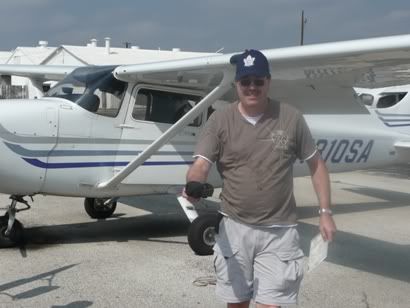
Biannual Flight Review
This was a ‘buddy roadtrip’ holiday to see my friend, Dan. We do these about twice a year for a week at a time to catch up and do stuff. I planned to visit San Antonio in Texas as my brother-in-law’s brother lives there. We met at the wedding and he is also a pilot and an FAA instructor who owns his own aircraft and rents it out through a local flying school. He made the mistake of inviting me out there for some flying so of course I took him up on it for this roadtrip.
My FAA BFR (Biannual Flight Review) was due in January 2010 anyway, so I decided to combine the checkride that the school would want anyway with a BFR. Martin is technically retired (from the USAF) but now works full time as a flight instructor at another school, so my original Monday date for a BFR was brought forward to Sunday, the day after I arrived in Texas from the UK. I knew I would be a bit ‘jet-lagged’ but I find it easier to cope with flying west than east, so thought I would be fine after a nights sleep.
Well, I was fine, but the weather wasn’t! I found it hard to believe that there could be anywhere on Earth that had lower cloudbases or crappier weather than the UK, but here it was! It was warm and humid, with very little wind and a cold front stalled right over Texas running west to east. There wasn’t so much a cloudbase, as there was visibility getting worse from about 2 miles on the ground to 1 mile at 200’ then into the soup at probably 600’ AGL. Martin asked how current I was on instruments. Well, I was IMC rated, but I let that lapse last year as I only fly a VFR capable aircraft, so I hadn’t flown on instruments for three years or so. I was happy that I still knew how but thought I would be a bit ‘rusty’. So my BFR was to be an IMC flight from San Antonio International to Fredericksburg to land and back again.
I had already done MY FAR revision on the flight over, so this was the flying bit.
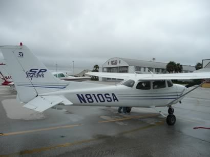
Martin showed me around his plane. It is a ‘round dials’ Cessna 172S dating from about 2002 – so pretty recent and in good condition, despite it’s heavy use by a flying school. It was pretty straightforward.
Martin filed a flight plan for IFR via a website and we saddled up. As San Antonio is a full international airport, it has more frequencies than you can shake a stick at. We started with ‘Clearance’ from whom we got taxi clearance, then onto ‘Ground’ who controlled ground movements. We did the run up checks and noticed that the Attitude Indicator was looking a bit wonky and lazy – not good as this is the ‘master instrument’ for IMC flying and only an idiot would fly into real IMC without it (yes, you CAN use ‘partial panel’ and we all train for it, but you really don’t want to have to do it for real unless you have to). After a few turns on the ground and revving the engine, the AI seemed fine, so we decided to proceed.
Martin handled the take off with me flying in the right seat on the way out and we would swap on the way back. Once at the top of climb at 5000’, Martin handed over to me for the relatively simple task of straight and level in IMC. I have to say that it all came back to me very quickly. Trim, trim and trim again to get it perfect, then hold the yoke lightly and get the scan going. I was managing to hold heading and height pretty well though I say it myself, mind you I did notice that I didn’t have much mental capacity for anything else, I guess that is what really being current in IMC will give you – the spare capacity to be able to chew gum at the same time (not to mention reading approach plates etc.!).
We were going to shoot the GPS approach into Fredericksburg – another first as I haven’t flown a GPS approach yet. They are widespread in the USA, but rare in the UK. Well, I managed that being talked through by Martin and we descended to minimums – I could see out of the corner of my eye the cloud breaking with dark patches below, we held at minimum for probably another 15 seconds then just broke clear to be rewarded by the runway in front of us with probably 700’ of height left to lose before the threshold! I love it when this stuff works! Martin took this landing as he had reservations about me doing my first landing from the right-hand seat in a strange aircraft after having flown in IMC – probably pretty wise!
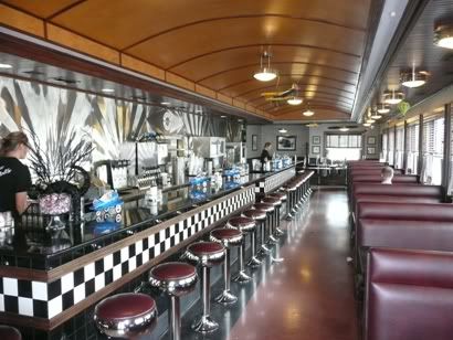
We landed and taxied in to a near deserted apron and shut down. We were only there for a ‘hundred dollar hamburger’, so the delights of Frederickburg (which is I am told a nice town with a museum devoted to Admiral Nimitz) would have to wait. But what a great airfield! There is a 1940’s style American Diner, complete with chrome stools and booths and the food was pretty good too – the vanilla shake was to die for! Then we walked next door to look at the ‘Hangar Hotel’.
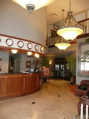
For $99 a night you can stay in this hotel designed to look like a 1940’s USAF officers club, again, what a great place, definitely one to take the wife to to redeem her low opinion of private aviation! I strongly recommend Gillespie County / Fredericksburg airfield (T82) as an overnight destination.
After lunch, we saddled up again as Martin filed for IFR back to another airfield near San Antonio for a few low level circuits, but there was a major SNAFU. As we taxied out, another plane arrived, landed, shut down and the pilots wandered off, but they didn’t close their flight plan. So we couldn’t get clearance to take-off as the system was showing someone on the instrument approach (the guy that had landed). This was compounded by the fact that there was another plane stuck in the hold awaiting clearance to shoot the instrument approach. Well, cut a long story short, we sat at the hold for take off with the engine running for literally 40 minutes while Martin tried again and again over the phone to get someone to clear us for departure.
We eventually got away, but time was wearing on so we changed the plan once airborne for a direct back to San Antonio International via the ILS. I flew again on instruments while we were vectored in, then past while approach landed ‘heavy metal’ instead of us. As the cloudbase was so low, we couldn’t use the shorter GA runway (12L) so had to use the main runway, 12R. Eventually we were vectored back and Martin shot the approach itself. Again we popped out at about 600’ AGL as I took control from the left-hand seat for the landing. The landing was OK, if a bit fast, so I had to flare off the excess speed, but in doing so, allowed the crosswind to push me slightly off centreline, not a drama, but a bit amateur of me.
Still, Martin was happy enough to sign me off for my BFR and for renting the aircraft. Now all I had to do was hope that this stalled front would clear for our planned departure date of Tuesday, two days away.
My FAA BFR (Biannual Flight Review) was due in January 2010 anyway, so I decided to combine the checkride that the school would want anyway with a BFR. Martin is technically retired (from the USAF) but now works full time as a flight instructor at another school, so my original Monday date for a BFR was brought forward to Sunday, the day after I arrived in Texas from the UK. I knew I would be a bit ‘jet-lagged’ but I find it easier to cope with flying west than east, so thought I would be fine after a nights sleep.
Well, I was fine, but the weather wasn’t! I found it hard to believe that there could be anywhere on Earth that had lower cloudbases or crappier weather than the UK, but here it was! It was warm and humid, with very little wind and a cold front stalled right over Texas running west to east. There wasn’t so much a cloudbase, as there was visibility getting worse from about 2 miles on the ground to 1 mile at 200’ then into the soup at probably 600’ AGL. Martin asked how current I was on instruments. Well, I was IMC rated, but I let that lapse last year as I only fly a VFR capable aircraft, so I hadn’t flown on instruments for three years or so. I was happy that I still knew how but thought I would be a bit ‘rusty’. So my BFR was to be an IMC flight from San Antonio International to Fredericksburg to land and back again.
I had already done MY FAR revision on the flight over, so this was the flying bit.
Martin showed me around his plane. It is a ‘round dials’ Cessna 172S dating from about 2002 – so pretty recent and in good condition, despite it’s heavy use by a flying school. It was pretty straightforward.
Martin filed a flight plan for IFR via a website and we saddled up. As San Antonio is a full international airport, it has more frequencies than you can shake a stick at. We started with ‘Clearance’ from whom we got taxi clearance, then onto ‘Ground’ who controlled ground movements. We did the run up checks and noticed that the Attitude Indicator was looking a bit wonky and lazy – not good as this is the ‘master instrument’ for IMC flying and only an idiot would fly into real IMC without it (yes, you CAN use ‘partial panel’ and we all train for it, but you really don’t want to have to do it for real unless you have to). After a few turns on the ground and revving the engine, the AI seemed fine, so we decided to proceed.
Martin handled the take off with me flying in the right seat on the way out and we would swap on the way back. Once at the top of climb at 5000’, Martin handed over to me for the relatively simple task of straight and level in IMC. I have to say that it all came back to me very quickly. Trim, trim and trim again to get it perfect, then hold the yoke lightly and get the scan going. I was managing to hold heading and height pretty well though I say it myself, mind you I did notice that I didn’t have much mental capacity for anything else, I guess that is what really being current in IMC will give you – the spare capacity to be able to chew gum at the same time (not to mention reading approach plates etc.!).
We were going to shoot the GPS approach into Fredericksburg – another first as I haven’t flown a GPS approach yet. They are widespread in the USA, but rare in the UK. Well, I managed that being talked through by Martin and we descended to minimums – I could see out of the corner of my eye the cloud breaking with dark patches below, we held at minimum for probably another 15 seconds then just broke clear to be rewarded by the runway in front of us with probably 700’ of height left to lose before the threshold! I love it when this stuff works! Martin took this landing as he had reservations about me doing my first landing from the right-hand seat in a strange aircraft after having flown in IMC – probably pretty wise!
We landed and taxied in to a near deserted apron and shut down. We were only there for a ‘hundred dollar hamburger’, so the delights of Frederickburg (which is I am told a nice town with a museum devoted to Admiral Nimitz) would have to wait. But what a great airfield! There is a 1940’s style American Diner, complete with chrome stools and booths and the food was pretty good too – the vanilla shake was to die for! Then we walked next door to look at the ‘Hangar Hotel’.
For $99 a night you can stay in this hotel designed to look like a 1940’s USAF officers club, again, what a great place, definitely one to take the wife to to redeem her low opinion of private aviation! I strongly recommend Gillespie County / Fredericksburg airfield (T82) as an overnight destination.
After lunch, we saddled up again as Martin filed for IFR back to another airfield near San Antonio for a few low level circuits, but there was a major SNAFU. As we taxied out, another plane arrived, landed, shut down and the pilots wandered off, but they didn’t close their flight plan. So we couldn’t get clearance to take-off as the system was showing someone on the instrument approach (the guy that had landed). This was compounded by the fact that there was another plane stuck in the hold awaiting clearance to shoot the instrument approach. Well, cut a long story short, we sat at the hold for take off with the engine running for literally 40 minutes while Martin tried again and again over the phone to get someone to clear us for departure.
We eventually got away, but time was wearing on so we changed the plan once airborne for a direct back to San Antonio International via the ILS. I flew again on instruments while we were vectored in, then past while approach landed ‘heavy metal’ instead of us. As the cloudbase was so low, we couldn’t use the shorter GA runway (12L) so had to use the main runway, 12R. Eventually we were vectored back and Martin shot the approach itself. Again we popped out at about 600’ AGL as I took control from the left-hand seat for the landing. The landing was OK, if a bit fast, so I had to flare off the excess speed, but in doing so, allowed the crosswind to push me slightly off centreline, not a drama, but a bit amateur of me.
Still, Martin was happy enough to sign me off for my BFR and for renting the aircraft. Now all I had to do was hope that this stalled front would clear for our planned departure date of Tuesday, two days away.
Subscribe to:
Posts (Atom)