Wednesday morning dawned much brighter with some clear bits in Austin as the cloud broke and lifted. The forecast was good, so we headed back the 60 or so miles to San Antonio. When we got to Wright Flyers, I got a blank look from the lady on reception and she said that my booking for all the three days had been cancelled. I said that I specifically spoke to the lady on duty yesterday and that she assured me that she was only cancelling one day. Then of course the ‘do you remember who you spoke to’ bit – I thought ‘Oh God, here we go’. Then one of the Wright Flyers senior guys that I met yesterday came up and asked me if everything was OK. I explained the situation and he simply smiled and said ‘Hey, no problems, we can fix this’. I overheard him say to the lady on reception ‘Make it happen’ as she set about clearing the plane of bookings. Screw-ups do happen, but it is how they are dealt with that makes the difference and I have to say Wright Flyers did very well in that regard – thanks guys!
While she was clearing the plane, I set about deciding where we could go bearing in mind the weather and route planning. The weather was worse further north, so back to Plan A and head east to the gulf coast and Galveston, which seems to be a nice island which also has an aircraft museum on-airport. I decided on a route that would avoid the Houston Class B airspace and so would swing a little south and allow us to fly up the interesting looking coast and inter coastal waterways, which I was told was pretty scenic. So my route was:
KSAT DCT VCT DCT PSX DCT KGLS
I estimated it would be some 200 nautical miles and take about 2:20 hours. Of course I would make life easy on myself and hop from VOR to VOR, easy to plot on the GPS and easy to follow on the VOR in the plane as a check and if the GPS reception failed. I had brought my old hand-held Garmin GPS Pilot 3, with it’s tiny screen, but it is easy to use. Of course I didn’t have the US database, so had to hand-crank the airports and VOR locations, so careful and easy does it, don’t want to get a wrong lat/long! I got a full weather brief, NOTAM’s and filed a flight plan through the absolutely excellent 1-800-WX BRIEF phone service – WHAT A FANTASTIC SERVICE THIS IS! This, ‘Flight Following’ and fantastic and usually free handling from many FBO’s make flying in the USA a real joy (not to mention the scenery).
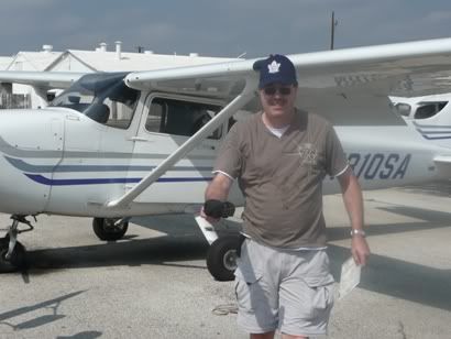
I had to complete a risk assessment sheet and a worksheet including weight and balance so that they could formally sign me out in the plane – very thorough of them. This I did as they escorted me out to the apron (I had no US FAA Id card, so an escort is mandatory now with the Homeland Security restrictions, especially as this was an international airport). The cloud was breaking nicely, with the cloudbase probably at about 2500’ and the tops at 4000’. Boy was it HOT though! The temperature was about 90 degrees and the humidity at least 95% - fairly normal for Texas I am told! I had the plane filled to the brim, which would take the overall weight nicely up to MAUW with myself and Dan (neither of us are particularly small or slight guys). I positioned everything and put the water in the ubiquitous cup holders then waited a few minutes for my flight plan departure time. We climbed in and closed the doors and opened the windows, but even so, we started to bake!
I called ‘Clearance’ as required and got taxi instructions for 12L as expected. I stayed with them until I completed the power checks and was ready to depart when they handed me off to the Tower. Mercifully, they quickly gave me a ‘clear for take-off’ as we were really sweating by now – I would not even like to think what an RV6 with it’s bubble canopy would be like over here! I powered up and took off. The tower started to vector me in the climb, then handed me over to ‘Departures’. I asked for and got the wonderfully ‘Flight Following’ service. For anyone who hasn’t flown in the UK, this is the sort of service you get from, say Farnborough Radar where they give you a squawk and provide traffic information when they can, but the real bonus is that they will automatically hand you over en-route, so all you have to do is change to the frequency they tell you, contact the new ‘Center’ giving them your callsign and that’s it! Often you keep the same squawk – wonderful!
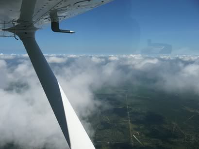
I climbed to 2000’ as that was all I was going to get for now. I was tempted to climb up through the broken cloud as the tops were only at probably 3500’ (which is the altitude I wanted as in the USA when flying VFR, you should fly at ‘odd plus 500’ going east and ‘even plus 500’ going west), but I decided to hold off for now as I didn’t want to get ‘stuck’ on-top and shoot an unfamiliar approach. However, as we approached Victoria, the cloud broke even more and started to lift. So I climbed to 2500’ then decided to climb on-top, which I got to at 3500’. By now the clouds were starting to spread out even more and became ‘scattered’.
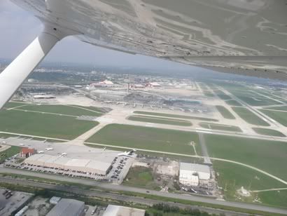
Flying overhead Victoria was a strange sensation. We were above their airspace so they weren’t worried about us, but what a huge airfield! We could see a Citation doing circuits, but that was about all. If someone had told me that was an international airport, I would have believed them!
Past the Victoria VOR, we set course for the PSX VOR which would take us to within sight of the coast. As we closed in on this, the clouds got thicker and went back to broken and got deeper, so I could either climb or go back underneath. I chose to go back down and was clear at 2500’. But then as we approached the coast, the base dropped even more and forced us down to 1800’, but I could see that over the actual coast is was ‘Sky Clear’ as is often the case, so I was hardly concerned. I avoided a prohibited area that stated it was for a static line holding a balloon up to 15000’ (yes – fifteen thousand feet), what kind of balloon was that!!!
I was called by Houston Center who were providing me with flight following asking what I was doing on altitude. I said I was dodging a few clouds to stay VFR, whereupon they said with poor radar coverage at the altitude I was on my own and should squawk 1200 – goodbye! No problem, not far to run, so I changed to listening watch on Galveston ASOS (automated weather broadcast). But all it said over and over again was ‘This is Galveston ASOS’. So I guess it wasn’t working properly, so I switched to Galveston Tower and listened in.
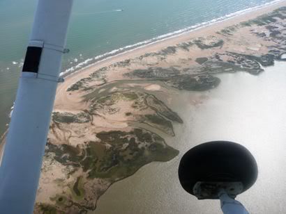
We hit the coast, which is not so much a coast as a mess of swamps, winding and tidal inter-coastal waterways and long, thin islands fronting the Gulf of Mexico. All of which made for some really great land and sea-scapes. We were completely clear of cloud, but as we didn’t have that far to run and were enjoying the view of the sea-scapes, I stayed at 2000’. The coast was devoid of any evidence of human habitation. This started to change as we got nearer to Galveston with the odd road, then some obviously planned developments with or without their own jetty onto a waterway.
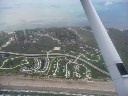
Once onto the very long (maybe 30 miles long) but thin (maybe 3 miles wide) Galveston Island, there were far more and some very classy residential developments. With 30 miles to run, I contacted Galveston tower for airfield information and joining. They were using runway 17 with right hand circuits and reporting the winds as 180 / 10-15. I was to join on the downwind leg. They were very quiet and I only heard two other aircraft on frequency as we approached, one helicopter and some sort of navy aircraft.
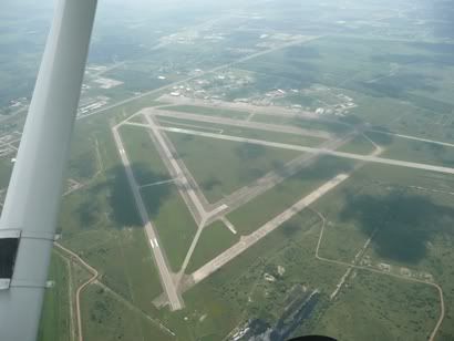
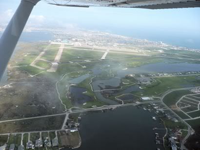
We spotted the airfield fairly easily with about 8 miles to run. The biggest of the runways has obviously recently been resurfaced in a very black tarmac, which showed up really well compared with the other runway and taxiways all in concrete the same colour as the sand. I joined into an empty pattern and was immediately cleared to land. We went out wide into the water between the mainland and the island and over the main bridge to the island. I settled on a good looking approach to runway 17. Flaps down and speed under control at 70kts with the target of 65 over the fence. This I did and flared nicely. Bit of a stall warning as we touched and I dealt with what felt like gusty conditions. We turned off and easily taxied to the ramp as the taxiways were not complex. I was about to park up when a guy driving a golf buggy and wearing shorts, a loud Hawaiian shirt, shorts and sandals marshalled us to a spot with tie downs – what a nice fellah!
We shutdown as quickly as we could and popped the doors and stumbled out, sweating profusely – all in the space of five minutes from touching down – damn it’s hot!
Well, it turns out that the airfield was badly flooded during Hurricane Ike in September 2008 which completely gutted the terminal and the aircraft museum. So the Galveston FBO were in some temporary huts. We were ushered in to air-conditioned bliss. Well, the FBO and the people here could not have been more friendly or helpful. They dished out bottled water, asked us what we wanted in fuel and within 5 minutes they were refuelling. They booked a hotel for us and later drove us both out there. This really is the best part of flying in the USA – wonderful!
But first we went to the Lone Star aircraft museum. This is on the edge of the airfield, but you have to go out of the gate to get there. We got ferried over in the golf cart of course. For a few dollars entrance fee, we saw the planes. The unique thing about them is that virtually every single one is in flying condition and is regularly flown giving people warbird experiences. The B17 was positively pristine as was the Corsair. There is a Liberator undergoing complete refurbishment. What a great museum, seeing aircraft that still fly. I couldn’t resist as bright aircraft themed Hawaiian shirt though.
A nice flight and well worth the effort. Lovely gulf coast scenery and a great airport.