Having now received ‘limited sign-off’ for the taildragger, my instructor wanted me to ‘do a few hours’ by myself to get comfortable with the RV6, then go back to him for some ‘serious crosswind training and full sign-off’. By limited, he means winds 10 kts or less and no more than 30 degrees off the runway heading.
So of course I booked a slot for the very next weekend. At the appointed time, the weather looks good, but the winds are well outside the prescribed limit. I didn’t even have to look them up on the METAR’s, just looking out of my bedroom window said 15G25!
So of course I booked a slot for the very next weekend. At the appointed time ……… well, you get the picture!
I have now booked a slot for this coming Saturday. I am praying to the weather goods for their favour. This will be the Saturday that all the Irish will be heading home from the Cheltenham Gold Cup, so it might be a bit busy with Biz Jets!
Not that the weather was particularly bad. Had I been flying a nosewheel aircraft, I would certainly have flown and not been worried about it at all. To be fair, once I have been fully signed-off and have confidence in crosswind landings, I would also ‘probably’ have flown the RV, especially as Gloucester airport has three runways and the wind cannot be more than 30 degrees off the runway heading anyway. But I can see that wind is a far bigger factor with tailwheel aircraft than with nosewheel and I will have to think quite carefully about wind at some of the large, single runway French airports (and particularly about alternates with more favourably aligned runways).
Planning for the Big Flying Trip 2008
On another subject, I have been planning and thinking through the ‘Big Flying Trip’ I am planning for August 2008. Actually, not a very ‘big’ trip at all due to serious constraints on holiday this year (just changed jobs, lower year 1 entitlement etc.).
I am planning a visit to see my buddy in Ottawa, then hire a C172 and fly for a four day tour to New York City then back via NY low level city tour, Niagara Falls and Toronto City Airport.
As I am not a hairy-ars*d sky god who thinks that planning is for students or low hour clear-sky-only wimps or who cares what Jeremy Clarkson thinks - I have been getting all the maps and AFD’s together and planning the routes and airfields etc. Yes, I know it’s in August and ages away, but for me the planning is fun and adds to the anticipation and makes sure I don’t miss out on anything.
Although I have flown in the USA, that was mainly training and I have not done any touring as such. So although I have read-up on radio procedures and flight services, I have not actually used the likes of Flight Following – so this will be something of another first for me. I have asked a few detailed questions of my American brother-in-law’s brother, who is an FAA instructor.
One thing I have noticed is how much clearer the UK maps are than the FAA ones and how much better the UK internet airfield facility is than the AFD paper books you have to buy. I know that there is an element of ‘what you are used to’, but even so! The Canadian and USA maps are a bit like Jeppesen VFR maps, the land is always tinted green or other colours to indicate relief.
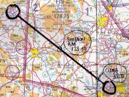
UK maps have land below 500’ as white and only tint for land above that altitude or for forests etc. (of course tinting for forests in Canada and USA would lead to maps almost entirely green anyway!). Its just that I find it a bit harder to mark up my track – I have taken to using pencil and marking the track with four parallel lines on the US maps, otherwise the track isn’t immediately obvious – for CAA maps, I use a medium ‘permanent’ marker in black and it stands out a treat.
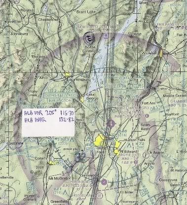
I also like to mark ‘balloons’ on the map to indicate actions I need to take at various points along the track, like altitude changes, who to speak to on the radio etc. In this way, I really don’t need a PLOG at all (although I usually do one, I find I rarely refer to it). The only way I have found of making this work on the US charts with sufficient clarity is to cut out the sticky part of post-it notes and stick that on the maps at the appropriate point. It works fine, it’s just a bit more fiddly, that’s all. I suppose on the upside, US maps cost a fraction of the UK ones.
Anyway, the planning is going well and I have all the routes and airports planned, marked up, printed out and in a folder etc. Flyer Forum has again been a wonderful source of information and I never cease to be amazed at where the forum members have flown – I swear if I planned to fly around Tibet, there would be a person on the forum who has already done so and is willing to provide valuable tips!
What I will do now is to double check everything, programme the waypoints in on my backup Garmin Pilot 3 backup GPS and start to figure out what happens after I shutdown with transport, hotels and the like.
And yes – I am already thinking about 2009! Maybe a trip around southern USA, or maybe the Baltic countries.